
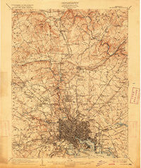
~ Baltimore MD topo map, 1:62500 scale, 15 X 15 Minute, Historical, 1904, updated 1915
Baltimore, Maryland, USGS topographic map dated 1904.
Includes geographic coordinates (latitude and longitude). This topographic map is suitable for hiking, camping, and exploring, or framing it as a wall map.
Printed on-demand using high resolution imagery, on heavy weight and acid free paper, or alternatively on a variety of synthetic materials.
Topos available on paper, Waterproof, Poly, or Tyvek. Usually shipping rolled, unless combined with other folded maps in one order.
- Product Number: USGS-5367938
- Free digital map download (high-resolution, GeoPDF): Baltimore, Maryland (file size: 10 MB)
- Map Size: please refer to the dimensions of the GeoPDF map above
- Weight (paper map): ca. 55 grams
- Map Type: POD USGS Topographic Map
- Map Series: HTMC
- Map Verison: Historical
- Cell ID: 50921
- Scan ID: 257291
- Imprint Year: 1915
- Survey Year: 1902
- Datum: Unstated
- Map Projection: Unstated
- Map published by United States Geological Survey
- Map Language: English
- Scanner Resolution: 600 dpi
- Map Cell Name: Baltimore
- Grid size: 15 X 15 Minute
- Date on map: 1904
- Map Scale: 1:62500
- Geographical region: Maryland, United States
Neighboring Maps:
All neighboring USGS topo maps are available for sale online at a variety of scales.
Spatial coverage:
Topo map Baltimore, Maryland, covers the geographical area associated the following places:
- Linhigh - Manor Springs - Eudowood - Big Spring - Television Hill - Town and Country North - Jones Valley - Sugarvale Estates - Westview Park - Mondawmin - Anton North - The Village - Brookwood - Cub Hill Farms - Anton Woods - Cloverfield Manor - Talbotts Choice - Knollwood - The Lakes - Graceland - Overlook - Lake - Woodmoor - Eastfield - Overlea - Dulaney Hills - Woodberry - Daybreak Estates - Cherry Hill - Goodnow Hill - Hunt Ridge - Autumn Wind - Hillstead - Cambria - Fulton - Brooklandville - Dun Rovin - Windsor Mill Manor - Lutherville - Dulaney Village - Bluegrass Heights - Springhill Farms - Valley View - College Hills - Kenwood Park - Dixon Hill - Parktowne - Laureldale - Catonsville - Butchers Hill - The Pines at Deep Run - Mount DeSales - Brooklandwood Estates - York Ridge - Calverton Heights - Cooperfield - Norwood Heights - Lakeland - Clarence Perkins Homes - Featherbed - Morrisville - Fox Ridge Estates - The Colony - Shawan Valley - Bloomsbury - Bridleshire - Baltimore - Falls Gable - Donnybrook - Eccleston - Notch Cliff - Long Meadows Estates - Chestnut Hill - Chapel Hill - Briarwood Farms - Arbutus - Ralston - The Falls - Tufton Ridge Estates - Oakleigh - Broadmoor - Thornleigh - Lauraville - Cockeysville - Brierleigh - Dundalk Mobile Home Court - Beaumont Park - Saint Helena - Jonathans Delight - Ashland - Chapel Ridge - West Edmondale - Morrell Park - Meadowcliff - The Beechs - Knollcrest Manor - Glenmont - Huntcrest Estates - Guilford - Martins Choice
- Map Area ID: AREA39.539.25-76.75-76.5
- Northwest corner Lat/Long code: USGSNW39.5-76.75
- Northeast corner Lat/Long code: USGSNE39.5-76.5
- Southwest corner Lat/Long code: USGSSW39.25-76.75
- Southeast corner Lat/Long code: USGSSE39.25-76.5
- Northern map edge Latitude: 39.5
- Southern map edge Latitude: 39.25
- Western map edge Longitude: -76.75
- Eastern map edge Longitude: -76.5


