
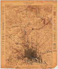
~ Baltimore MD topo map, 1:62500 scale, 15 X 15 Minute, Historical, 1899
Baltimore, Maryland, USGS topographic map dated 1899.
Includes geographic coordinates (latitude and longitude). This topographic map is suitable for hiking, camping, and exploring, or framing it as a wall map.
Printed on-demand using high resolution imagery, on heavy weight and acid free paper, or alternatively on a variety of synthetic materials.
Topos available on paper, Waterproof, Poly, or Tyvek. Usually shipping rolled, unless combined with other folded maps in one order.
- Product Number: USGS-5367928
- Free digital map download (high-resolution, GeoPDF): Baltimore, Maryland (file size: 10 MB)
- Map Size: please refer to the dimensions of the GeoPDF map above
- Weight (paper map): ca. 55 grams
- Map Type: POD USGS Topographic Map
- Map Series: HTMC
- Map Verison: Historical
- Cell ID: 50921
- Scan ID: 257285
- Survey Year: 1898
- Datum: Unstated
- Map Projection: Unstated
- Map published by United States Geological Survey
- Map Language: English
- Scanner Resolution: 600 dpi
- Map Cell Name: Baltimore
- Grid size: 15 X 15 Minute
- Date on map: 1899
- Map Scale: 1:62500
- Geographical region: Maryland, United States
Neighboring Maps:
All neighboring USGS topo maps are available for sale online at a variety of scales.
Spatial coverage:
Topo map Baltimore, Maryland, covers the geographical area associated the following places:
- Waterspout - Village of Cross Keys - Holabird Homes (historical) - Greenspring - Shawan at Hunt Valley - Loch Raven - Woodhome Heights - Patapsco Woods - Stab - Armagh - Oak Hill - The Cloisters at Charles - Little Italy - Lakeland - Arbutus - Walbrook - Greengate - Armistead Homes - Eden Roc - Ashland - Cowpen - Colgate - Dickeyville - Lakeside - Apple Ridge - Greene Tree - Broadmoor - Stevenson - O'Donnell Heights - Baltimore - Colgate - Orangeville - Timberline Park - Sheppard (historical) - Kenwood - Catonsville Manor - Knettishall - Brigadoon - Windsor Mill Manor - Leisure Hill - Wellwood - Rosedale - Dulaney Gate - Dorchester Heights - Towson Estates - Woodlawn - Ranchleigh - Donnybrook - Oak Summit - Tufton Ridge Estates - Bare Hills - Village of Vanderway - West Baltimore - Brooklandwood Estates - Fallstaff - The Village - Graceland - Summerfield (historical) - Fullerton Heights - Forest Park - Franklintown - Manor Springs - Providence - Elmwood - Brookwood - Manor Oaks - Lowell Ridge - Broadmeade - Morgan Park - Mays Chapel Village - Pimlico - Milestone Manor - Padonia - Montebello Park - Bonnie Ridge - Valley Stream - Worthington Club Estates - Haverford - Charles Village - Rodgers Forge - Rosedale Terrace - Long Meadows Estates - Summit Park - Gwynn Oak - Harborview - Brooks Hill - Chapel Hill - Edmondson Ridge - Britinay Hills - West Hills - Hunters Hill - Violetville - Cloverfield Manor - Revere Park - Marble Hill - Hollins (historical) - Valley Heights - West Edmondale - Clarence Perkins Homes - Powhatan
- Map Area ID: AREA39.539.25-76.75-76.5
- Northwest corner Lat/Long code: USGSNW39.5-76.75
- Northeast corner Lat/Long code: USGSNE39.5-76.5
- Southwest corner Lat/Long code: USGSSW39.25-76.75
- Southeast corner Lat/Long code: USGSSE39.25-76.5
- Northern map edge Latitude: 39.5
- Southern map edge Latitude: 39.25
- Western map edge Longitude: -76.75
- Eastern map edge Longitude: -76.5


