
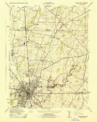
~ Hagerstown MD topo map, 1:31680 scale, 7.5 X 7.5 Minute, Historical, 1944
Hagerstown, Maryland, USGS topographic map dated 1944.
Includes geographic coordinates (latitude and longitude). This topographic map is suitable for hiking, camping, and exploring, or framing it as a wall map.
Printed on-demand using high resolution imagery, on heavy weight and acid free paper, or alternatively on a variety of synthetic materials.
Topos available on paper, Waterproof, Poly, or Tyvek. Usually shipping rolled, unless combined with other folded maps in one order.
- Product Number: USGS-5367702
- Free digital map download (high-resolution, GeoPDF): Hagerstown, Maryland (file size: 7 MB)
- Map Size: please refer to the dimensions of the GeoPDF map above
- Weight (paper map): ca. 55 grams
- Map Type: POD USGS Topographic Map
- Map Series: HTMC
- Map Verison: Historical
- Cell ID: 18902
- Scan ID: 257103
- Woodland Tint: Yes
- Aerial Photo Year: 1943
- Datum: NAD27
- Map Projection: Polyconic
- Map published by United States Army Corps of Engineers
- Map published by United States Department of War
- Map Language: English
- Scanner Resolution: 600 dpi
- Map Cell Name: Hagerstown
- Grid size: 7.5 X 7.5 Minute
- Date on map: 1944
- Map Scale: 1:31680
- Geographical region: Maryland, United States
Neighboring Maps:
All neighboring USGS topo maps are available for sale online at a variety of scales.
Spatial coverage:
Topo map Hagerstown, Maryland, covers the geographical area associated the following places:
- Good Acres - Spring Valley - Fairgreen Acres - Robinwood - Sycamore Heights - Northaven Mobile Home Park - Cedar Hills - Forest Hills - Terrace Hills - Trengail Manor - Frederick Manor - Sunset Acres - Clearview - Wingerton - Bridgeport - Carroll Heights - Paramount - Hamilton Park - Wood Point - Hyde Park - Countryside - Fountain Head Heights - Colonial Park - Green Hill Acres - Weller Farm - Chewsville - Maugansville - Security - Winding Creek South - Hunter Hill - Fortney Mobile Home Park - Jefferson Heights - State Line - Fiddlesburg - Lurose Estates - Hagerstown - Northridge Manor - Long Meadow - Fountain Head - Orchard Hills - Reid - Paramount Manor - Miller Chapel - Potomac Heights - Woodlands - Potomac Manor
- Map Area ID: AREA39.7539.625-77.75-77.625
- Northwest corner Lat/Long code: USGSNW39.75-77.75
- Northeast corner Lat/Long code: USGSNE39.75-77.625
- Southwest corner Lat/Long code: USGSSW39.625-77.75
- Southeast corner Lat/Long code: USGSSE39.625-77.625
- Northern map edge Latitude: 39.75
- Southern map edge Latitude: 39.625
- Western map edge Longitude: -77.75
- Eastern map edge Longitude: -77.625


