
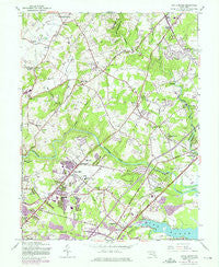
~ White Marsh MD topo map, 1:24000 scale, 7.5 X 7.5 Minute, Historical, 1951, updated 1975
White Marsh, Maryland, USGS topographic map dated 1951.
Includes geographic coordinates (latitude and longitude). This topographic map is suitable for hiking, camping, and exploring, or framing it as a wall map.
Printed on-demand using high resolution imagery, on heavy weight and acid free paper, or alternatively on a variety of synthetic materials.
Topos available on paper, Waterproof, Poly, or Tyvek. Usually shipping rolled, unless combined with other folded maps in one order.
- Product Number: USGS-5367520
- Free digital map download (high-resolution, GeoPDF): White Marsh, Maryland (file size: 13 MB)
- Map Size: please refer to the dimensions of the GeoPDF map above
- Weight (paper map): ca. 55 grams
- Map Type: POD USGS Topographic Map
- Map Series: HTMC
- Map Verison: Historical
- Cell ID: 48706
- Scan ID: 257009
- Imprint Year: 1975
- Woodland Tint: Yes
- Photo Revision Year: 1974
- Aerial Photo Year: 1974
- Field Check Year: 1949
- Datum: NAD27
- Map Projection: Polyconic
- Map published by United States Geological Survey
- Map Language: English
- Scanner Resolution: 600 dpi
- Map Cell Name: White Marsh
- Grid size: 7.5 X 7.5 Minute
- Date on map: 1951
- Map Scale: 1:24000
- Geographical region: Maryland, United States
Neighboring Maps:
All neighboring USGS topo maps are available for sale online at a variety of scales.
Spatial coverage:
Topo map White Marsh, Maryland, covers the geographical area associated the following places:
- Mountvista - Exeter Green - Silver Hill Farm - Ferguson Meadows - Hallfield Manor - Bonaparte Estates - Silver Woods - Woodlyn Meadows - Forge Acres - Lawrence Hill - Franklinville - Jenkins - The Meadows - Fork - Oakhurst - Chapel Manor - Necker - Dunwood - Germantown - Perry Hall Estates - Walnut Hills Estates - Long Green Woods - Reckford - Wesley Woods - Nottingham Woods - Gunpowder Estates - White Marsh Station - Darleigh Manor - Gunpowder - Kingswood - Forge Heights - Correlli Estates - Perry Hall Village - Hydes - Fullerton Farms - Regwood - Oaklyn Manor - Bagley - Darryl Gardens - Joppa View - Lereley - Perry View - Cedarside Farm - Upper Falls - Greenwood - Kings Country - Joppa Vale - Perry Hall Manor - Tremper Farm - Batter Brook Farms - Baldwin - Whippoorwill Trailer Park - Silver Meadow - Harford Heights - Valleybrook - Silver Spring Station - Bradshaw - Mount Vista Estates - Harmony Hills - Indian Princess - Woodcrest - Gittings - Baldwin Estates - Sylvania Mobile Home Park - West Grove - Pinedale - Berryhill - Stoneybrook - Greenwood Manor - Hartley (historical) - Margate - Lynchs Corner - Glenbauer - Perry Hall Park - Tarton Hill - Perry Hall - Laurelvale - White Marsh - Chapel Valley - Richlyn Manor - Glen Arm - Bird River Beach - Hines Estates - Silvergate East - Jerusalem - Arbour Green - Southfield at Whitemarsh - Spring Hill - Silver Gate Village - Stockton - Bagleys Venture - Brookhurst - Village of Silver Hall - Lincrest - Merrywood - Pleasant Hills - Kingsville - Perryvale - Northwind Farms - Clear Acres
- Map Area ID: AREA39.539.375-76.5-76.375
- Northwest corner Lat/Long code: USGSNW39.5-76.5
- Northeast corner Lat/Long code: USGSNE39.5-76.375
- Southwest corner Lat/Long code: USGSSW39.375-76.5
- Southeast corner Lat/Long code: USGSSE39.375-76.375
- Northern map edge Latitude: 39.5
- Southern map edge Latitude: 39.375
- Western map edge Longitude: -76.5
- Eastern map edge Longitude: -76.375


