
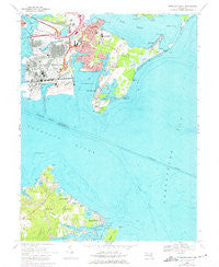
~ Sparrows Point MD topo map, 1:24000 scale, 7.5 X 7.5 Minute, Historical, 1969, updated 1975
Sparrows Point, Maryland, USGS topographic map dated 1969.
Includes geographic coordinates (latitude and longitude). This topographic map is suitable for hiking, camping, and exploring, or framing it as a wall map.
Printed on-demand using high resolution imagery, on heavy weight and acid free paper, or alternatively on a variety of synthetic materials.
Topos available on paper, Waterproof, Poly, or Tyvek. Usually shipping rolled, unless combined with other folded maps in one order.
- Product Number: USGS-5367292
- Free digital map download (high-resolution, GeoPDF): Sparrows Point, Maryland (file size: 15 MB)
- Map Size: please refer to the dimensions of the GeoPDF map above
- Weight (paper map): ca. 55 grams
- Map Type: POD USGS Topographic Map
- Map Series: HTMC
- Map Verison: Historical
- Cell ID: 42412
- Scan ID: 256877
- Imprint Year: 1975
- Woodland Tint: Yes
- Photo Revision Year: 1974
- Aerial Photo Year: 1966
- Field Check Year: 1969
- Datum: NAD27
- Map Projection: Polyconic
- Map published by United States Geological Survey
- Map Language: English
- Scanner Resolution: 600 dpi
- Map Cell Name: Sparrows Point
- Grid size: 7.5 X 7.5 Minute
- Date on map: 1969
- Map Scale: 1:24000
- Geographical region: Maryland, United States
Neighboring Maps:
All neighboring USGS topo maps are available for sale online at a variety of scales.
Spatial coverage:
Topo map Sparrows Point, Maryland, covers the geographical area associated the following places:
- Fairview - Bodkin Manor - Venice on the Bay - Chesapeake Terrace - Bayshore (historical) - Baywood Mobile Home Park - Fort Howard - Water View - Belhaven Woods - Fitzell (historical) - Darinton (historical) - Pine Crest North - Hampton Chase - Springdale - Edgemere - Penwood Mobile Home Park - Belhaven Beach - Ramona Beach - Lynch Point - Hickory Point - Poplar Ridge - Rockwood Beach - Kurtz Beach - Bayside Beach - Chase Wood Run - Fairhaven Beach - Pine Crest West - Lincoln Mobile Home Park - Maryland Beach - Paradise Beach - Fitzell - Rock Creek Park - Lodge Forest - Sparrows Point - Bay Shore Park (historical) - Alloway - Pasadena Beach - Penwood Park (historical) - Swan Point - Bear Creek Junction - Pinehurst Harbour
- Map Area ID: AREA39.2539.125-76.5-76.375
- Northwest corner Lat/Long code: USGSNW39.25-76.5
- Northeast corner Lat/Long code: USGSNE39.25-76.375
- Southwest corner Lat/Long code: USGSSW39.125-76.5
- Southeast corner Lat/Long code: USGSSE39.125-76.375
- Northern map edge Latitude: 39.25
- Southern map edge Latitude: 39.125
- Western map edge Longitude: -76.5
- Eastern map edge Longitude: -76.375


