
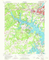
~ South River MD topo map, 1:24000 scale, 7.5 X 7.5 Minute, Historical, 1957, updated 1971
South River, Maryland, USGS topographic map dated 1957.
Includes geographic coordinates (latitude and longitude). This topographic map is suitable for hiking, camping, and exploring, or framing it as a wall map.
Printed on-demand using high resolution imagery, on heavy weight and acid free paper, or alternatively on a variety of synthetic materials.
Topos available on paper, Waterproof, Poly, or Tyvek. Usually shipping rolled, unless combined with other folded maps in one order.
- Product Number: USGS-5367276
- Free digital map download (high-resolution, GeoPDF): South River, Maryland (file size: 13 MB)
- Map Size: please refer to the dimensions of the GeoPDF map above
- Weight (paper map): ca. 55 grams
- Map Type: POD USGS Topographic Map
- Map Series: HTMC
- Map Verison: Historical
- Cell ID: 42284
- Scan ID: 256869
- Imprint Year: 1971
- Woodland Tint: Yes
- Photo Revision Year: 1970
- Aerial Photo Year: 1970
- Field Check Year: 1957
- Survey Year: 1944
- Datum: NAD27
- Map Projection: Polyconic
- Map published by United States Army Corps of Engineers
- Map Language: English
- Scanner Resolution: 600 dpi
- Map Cell Name: South River
- Grid size: 7.5 X 7.5 Minute
- Date on map: 1957
- Map Scale: 1:24000
- Geographical region: Maryland, United States
Neighboring Maps:
All neighboring USGS topo maps are available for sale online at a variety of scales.
Spatial coverage:
Topo map South River, Maryland, covers the geographical area associated the following places:
- Greenbriar - Southdown Estates - Tarzan Forest - Hidden Cove - Baytowne Village - Primrose Acres - Londontowne - Gingerville - Beverly Beach - Harkness Creek Park - North River Forest - Loretta Heights - River Club Estates - Eatons Landing - The Ridges - Annapolis Overlook - Lusby Crossroads - Old Cedar Point - Market Quay - West Woods - Cape Loch Haven - Heritage Harbour - Captains Walk - Mayo - Berkshire - Riva Farms - Bestgate - Oak Court - South River - Lincoln Heights - Riverview Manor - Rolling Knolls - Parole - Turnbull Estates - Parvilla - South River Estates - Greenbriar Gardens - Marriott Hill - Rundelac Farm - Wilelinor Estates - Tameron Hall - Riva Woods - Bon Haven - Dorsey Heights - Autumn Chase at Riva Trace - Admiral Heights - Harbor View - Romar Estates - Bywater Estates - South Haven - Gentry - Harbor Hills - Chestnut Hills - Jacksons Corner - Wetheridge Estates - Knightsbridge - Painters Hill - Holly Hill Harbor - Riva Trace - Oakbluff - Eagles Passages - Germantown - Loch Haven Beach - Heritage - Avila - Harwood Estates - Forest Villa - Donovans Pier - The Ridings - Harness Woods - Truxton Heights - South River Heights - Birdsville - Coxby Estates - The Courtyards - Homewood - Selby Beach - Threemile Oak Corner - Robinwood - Hunt Meadows - Annapolis Landing - Greenwood Acres - Withernsea - South Down Shores - Clubhouse Estates - Riva - Broadview Estates - Glen Isle - Carrs Ridge - Poplar Point - Cape Saint John - Steuart Corner - Edgewater - Weems Creek - Mariners Cove - South River Towers - Pine Whiff Beach - Glebe Heights - Collison Corner - Ashley
- Map Area ID: AREA3938.875-76.625-76.5
- Northwest corner Lat/Long code: USGSNW39-76.625
- Northeast corner Lat/Long code: USGSNE39-76.5
- Southwest corner Lat/Long code: USGSSW38.875-76.625
- Southeast corner Lat/Long code: USGSSE38.875-76.5
- Northern map edge Latitude: 39
- Southern map edge Latitude: 38.875
- Western map edge Longitude: -76.625
- Eastern map edge Longitude: -76.5


