
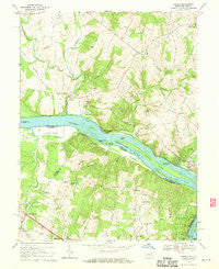
~ Seneca MD topo map, 1:24000 scale, 7.5 X 7.5 Minute, Historical, 1968, updated 1970
Seneca, Maryland, USGS topographic map dated 1968.
Includes geographic coordinates (latitude and longitude). This topographic map is suitable for hiking, camping, and exploring, or framing it as a wall map.
Printed on-demand using high resolution imagery, on heavy weight and acid free paper, or alternatively on a variety of synthetic materials.
Topos available on paper, Waterproof, Poly, or Tyvek. Usually shipping rolled, unless combined with other folded maps in one order.
- Product Number: USGS-5367232
- Free digital map download (high-resolution, GeoPDF): Seneca, Maryland (file size: 14 MB)
- Map Size: please refer to the dimensions of the GeoPDF map above
- Weight (paper map): ca. 55 grams
- Map Type: POD USGS Topographic Map
- Map Series: HTMC
- Map Verison: Historical
- Cell ID: 40567
- Scan ID: 256847
- Imprint Year: 1970
- Woodland Tint: Yes
- Aerial Photo Year: 1963
- Field Check Year: 1968
- Datum: NAD27
- Map Projection: Polyconic
- Map published by United States Geological Survey
- Map Language: English
- Scanner Resolution: 600 dpi
- Map Cell Name: Seneca
- Grid size: 7.5 X 7.5 Minute
- Date on map: 1968
- Map Scale: 1:24000
- Geographical region: Maryland, United States
Neighboring Maps:
All neighboring USGS topo maps are available for sale online at a variety of scales.
Spatial coverage:
Topo map Seneca, Maryland, covers the geographical area associated the following places:
- Dranesville - Travilah Acres - Esworthy Estates - Woodbyran Farms - Pioneer Hills - Deakins Range - Travilah Meadows - Ridgeland Farm Estates - Potomac Chase Estates - Polo Club Estates - Quail Run - Esworthy Park - Herndon Junction - Fox Hills North - Stoney Creek Estates - Seneca - Browns Corner - Leighs - Tobytown - Hartley Hall Estates - Stoney Creek Farm - Willow Ridge - Ancient Oak - Darnestown Hills - Highlands of Darnestown - Ancient Oak West - Bondbrook - Brookmead - Riverwood - Rive Gauche Estates - North Potomac - Rushville - Harlow - Farmlands - Windmill Farm - Quince Orchard - Estates at Rivers Edge - Seneca Highlands - Potomac Park Estate - Mills Farm East - Harvest Hunt Farm - Darnestown Knolls - Ancient Oak North - Brookmead North - Darnestown - Lake Potomac - Mills Farm - Deanwood - Beallmount - Spring Meadows - Travilah - Potomac Grove - Potomac Chase - Mountain View Estates - Quince Orchard Knolls - Lowes Island - Belvedere - Mitchells Range - Glen Query - Fox Hills Green
- Map Area ID: AREA39.12539-77.375-77.25
- Northwest corner Lat/Long code: USGSNW39.125-77.375
- Northeast corner Lat/Long code: USGSNE39.125-77.25
- Southwest corner Lat/Long code: USGSSW39-77.375
- Southeast corner Lat/Long code: USGSSE39-77.25
- Northern map edge Latitude: 39.125
- Southern map edge Latitude: 39
- Western map edge Longitude: -77.375
- Eastern map edge Longitude: -77.25


