
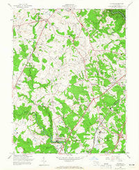
~ Savage MD topo map, 1:24000 scale, 7.5 X 7.5 Minute, Historical, 1957, updated 1965
Savage, Maryland, USGS topographic map dated 1957.
Includes geographic coordinates (latitude and longitude). This topographic map is suitable for hiking, camping, and exploring, or framing it as a wall map.
Printed on-demand using high resolution imagery, on heavy weight and acid free paper, or alternatively on a variety of synthetic materials.
Topos available on paper, Waterproof, Poly, or Tyvek. Usually shipping rolled, unless combined with other folded maps in one order.
- Product Number: USGS-5367210
- Free digital map download (high-resolution, GeoPDF): Savage, Maryland (file size: 12 MB)
- Map Size: please refer to the dimensions of the GeoPDF map above
- Weight (paper map): ca. 55 grams
- Map Type: POD USGS Topographic Map
- Map Series: HTMC
- Map Verison: Historical
- Cell ID: 40053
- Scan ID: 256835
- Imprint Year: 1965
- Woodland Tint: Yes
- Aerial Photo Year: 1955
- Field Check Year: 1957
- Survey Year: 1943
- Datum: NAD27
- Map Projection: Polyconic
- Map published by United States Army Corps of Engineers
- Map Language: English
- Scanner Resolution: 600 dpi
- Map Cell Name: Savage
- Grid size: 7.5 X 7.5 Minute
- Date on map: 1957
- Map Scale: 1:24000
- Geographical region: Maryland, United States
Neighboring Maps:
All neighboring USGS topo maps are available for sale online at a variety of scales.
Spatial coverage:
Topo map Savage, Maryland, covers the geographical area associated the following places:
- Aladdin Village Trailer Park - Garrian Orchards - Rosemont - Sebring - Asbury Woods - Georgetown - Huntington East - Wellington Estates - MacGills Common - Howard Hills - Savage - Glen Court - Aladdin Village - Nordeau - Orange Grove (historical) - The Birches - Cedars - Lennox Park - The Pines - Robinsons Promise - Timber Run - Dasher Green - Kings Meade - Fort George G Mead Junction - Elkhorn - Glenmar - Annetta Gardens - Worthington - Heritage Woods - Deep Run Park - Allview Estates - Woodleigh - Thompsons Purchase - Valley View - Hanover Hills - Jessup - Pfeiffer Corners - Mission Heights - Stevens Forest - Guilford - Springwood - Pleasant View - Whitehurst - Cardinal Forest - Columbia Hills - Font Hill - Locust Park - Donleigh - Champion Forest - Columbia - Lillys Addition - Stonebrook - Maple Trailer Park - Locust Manor - Marshalee Estates - Woodland Village - Thunder Hill - Guilford Downs - Glenshire Towne - Wardens Landing - Glen Oaks - Brampton Hills - Glenmont - Guilford Square - Phelps Luck - Jonestown - Village of Deep Run - Magnolia (historical) - Peter Harmond Acres - Owen Brown - Hopewell - Montevideo - Aspenwood - Bonnie Acres - Carriage Hills - Village of Dorseys Search - Campbell - Long Reach - Brentwood Manor - Waterloo - Running Brook - Brightfield - Jeffers Hill - Bonnie Brae - North Laurel - Montgomery Run - Villa Heights - Sharewood Acres - Washington Manor - Bryant Woods - Arrowhead - Autumn Woods - Sewells Orchard - Evemar Mobile Home Park - Montgomery Knolls - Oak View Village - Warfields Range - Wheatfield Way - Tall Pines Trailer Park - Huntington
- Map Area ID: AREA39.2539.125-76.875-76.75
- Northwest corner Lat/Long code: USGSNW39.25-76.875
- Northeast corner Lat/Long code: USGSNE39.25-76.75
- Southwest corner Lat/Long code: USGSSW39.125-76.875
- Southeast corner Lat/Long code: USGSSE39.125-76.75
- Northern map edge Latitude: 39.25
- Southern map edge Latitude: 39.125
- Western map edge Longitude: -76.875
- Eastern map edge Longitude: -76.75


