
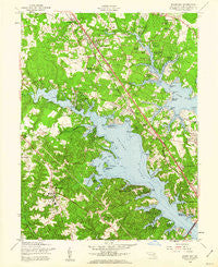
~ Round Bay MD topo map, 1:24000 scale, 7.5 X 7.5 Minute, Historical, 1956, updated 1960
Round Bay, Maryland, USGS topographic map dated 1956.
Includes geographic coordinates (latitude and longitude). This topographic map is suitable for hiking, camping, and exploring, or framing it as a wall map.
Printed on-demand using high resolution imagery, on heavy weight and acid free paper, or alternatively on a variety of synthetic materials.
Topos available on paper, Waterproof, Poly, or Tyvek. Usually shipping rolled, unless combined with other folded maps in one order.
- Product Number: USGS-5367170
- Free digital map download (high-resolution, GeoPDF): Round Bay, Maryland (file size: 13 MB)
- Map Size: please refer to the dimensions of the GeoPDF map above
- Weight (paper map): ca. 55 grams
- Map Type: POD USGS Topographic Map
- Map Series: HTMC
- Map Verison: Historical
- Cell ID: 38725
- Scan ID: 256813
- Imprint Year: 1960
- Woodland Tint: Yes
- Aerial Photo Year: 1955
- Field Check Year: 1956
- Survey Year: 1944
- Datum: NAD27
- Map Projection: Polyconic
- Map published by United States Army Corps of Engineers
- Map Language: English
- Scanner Resolution: 600 dpi
- Map Cell Name: Round Bay
- Grid size: 7.5 X 7.5 Minute
- Date on map: 1956
- Map Scale: 1:24000
- Geographical region: Maryland, United States
Neighboring Maps:
All neighboring USGS topo maps are available for sale online at a variety of scales.
Spatial coverage:
Topo map Round Bay, Maryland, covers the geographical area associated the following places:
- Whitneys Landing - West Magothy Manor - Laurel Acres - Rolling Hills - Indian Village - Asberry (historical) - Old County Estates - Crystal Beach - Bendale - Harting Estates - Arden on the Severn - Ross Cove - Clumber - Terrace Gardens - Woytych - Dunstable Green - Palisades on the Severn - Pack Town - Windrush Farm - Selby Grove - Brightview Woods - Smugglers Cove - Nottingham - Chartridge - Severn Landing - Saltworks on the Severn - Kilmarnock - Earleigh Heights - Severn Heights - Shipleys Choice - Dunkeld Manor - Briar Cliff on the Severn - Severn Grove - Little John - Beachwood Forest - Cresston Park - Millhausens - Parkview - Omar (historical) - Barrington Manor - Round Bay View - Raintree - Duffield - Cape McKinsey - Jacobsville - Herald Harbor - Oak Hollow - Marabrooke - Gotts - Sherwood Forest - Chatham Hills - Bluff Point - Rugby Hall Estates - Pasadena Manor - Woodlore - Epping Forest Manor - Windy Knolls - Trinity Farms - Brookfield - Glen Oban - Hidden Hills - Epping Forest - Hollywood - Severndale - Kalmia Ridge - Hampton Manor - Harbor Oaks - Ben Oaks - Manhattan Beach - Carriage Hills - North Cape Arthur - Summer Hill Trailer Park - Brightwood Terrace - Rugby Hall - Severn Forest - Rubert Manor - Chartwood - Indian Landing Estates - Joyce Acres - Norwich Acres - Tall Timbers - Chesterfield - Belleview Estates - Carrollton Manor - Kensington - Lake Forest - Oak Grove - Severna Gardens - Oakleigh Forest - Joyce - Old Severna Park - Allenville - Magothy Estates - Fairoaks - Cape Arthur - West Severna Park - Longmeadow North - Lakeland - Fernbrook - The Woods
- Map Area ID: AREA39.12539-76.625-76.5
- Northwest corner Lat/Long code: USGSNW39.125-76.625
- Northeast corner Lat/Long code: USGSNE39.125-76.5
- Southwest corner Lat/Long code: USGSSW39-76.625
- Southeast corner Lat/Long code: USGSSE39-76.5
- Northern map edge Latitude: 39.125
- Southern map edge Latitude: 39
- Western map edge Longitude: -76.625
- Eastern map edge Longitude: -76.5


