
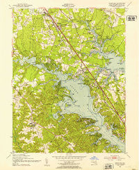
~ Round Bay MD topo map, 1:24000 scale, 7.5 X 7.5 Minute, Historical, 1949, updated 1953
Round Bay, Maryland, USGS topographic map dated 1949.
Includes geographic coordinates (latitude and longitude). This topographic map is suitable for hiking, camping, and exploring, or framing it as a wall map.
Printed on-demand using high resolution imagery, on heavy weight and acid free paper, or alternatively on a variety of synthetic materials.
Topos available on paper, Waterproof, Poly, or Tyvek. Usually shipping rolled, unless combined with other folded maps in one order.
- Product Number: USGS-5367166
- Free digital map download (high-resolution, GeoPDF): Round Bay, Maryland (file size: 13 MB)
- Map Size: please refer to the dimensions of the GeoPDF map above
- Weight (paper map): ca. 55 grams
- Map Type: POD USGS Topographic Map
- Map Series: HTMC
- Map Verison: Historical
- Cell ID: 38725
- Scan ID: 256811
- Imprint Year: 1953
- Woodland Tint: Yes
- Aerial Photo Year: 1949
- Field Check Year: 1949
- Datum: NAD27
- Map Projection: Polyconic
- Map published by United States Army Corps of Engineers
- Map Language: English
- Scanner Resolution: 600 dpi
- Map Cell Name: Round Bay
- Grid size: 7.5 X 7.5 Minute
- Date on map: 1949
- Map Scale: 1:24000
- Geographical region: Maryland, United States
Neighboring Maps:
All neighboring USGS topo maps are available for sale online at a variety of scales.
Spatial coverage:
Topo map Round Bay, Maryland, covers the geographical area associated the following places:
- Kilmarnock - Hickory Hills - Selby Grove - Cape Arthur - Brookfield on the Magothy - Quail Run - Sunrise Beach - Chesterfield - Kalmia Ridge - Luce Creek - Linstead-on-the-Severn - Epping Forest Manor - Brookfield - Lark Hill - Asberry (historical) - Severna Forest - Capri Estates - Oak Hollow - Benfield - Elvaton - North Cape Arthur - Glen Oban - Hollywood - Oak Grove - Evergreen Estates - Belvedere Heights - College Hills - Carriage Hills - Sabrina Park - Norwich Acres - Duffield - Round Bay - Riverdale Forest - Woodlore - Colchester on the Severn - Rubert Manor - Old Mill - Lake Forest - Evans Hill - Chartridge - Rivendell - Indian Landing Estates - Joyce Acres - Omar (historical) - Spring Fields - Tebbston - Divinity Cove - Chatham Hills - Foxhollow - Honeysuckle Ridge - Pohlman Point - Barrington Manor - Manhattan Beach - Pasadena - Swan Point Estates - Frost - Gotts - Pines-on-Severn - Woytych - Waterbury Heights - Parkview - Severn Grove - Willowbrook - Indian Creek Estates - Berrywood West - Lourds Manor - Ravenshead - Brightwood - Clumber - Summerhill Park - Severn Heights - Lakewood - Cool Pond - Beachwood Forest - Ben Oaks - Harbor Oaks - Whippoorwill Estates - Saltworks on the Severn - Robinson - College Manor - Jones - Manhattan Manor - Holly Point - Cape McKinsey - Pine Bluff - Terrace Gardens - Severna Gardens - Cypress Creek - Old Severna Park - Shipleys Choice - Captains Cove - Deerfield - Severnview - Elvaton Acres - Zeman - Little John - Rolling Hills - Robin Hood Hill - Magothy Forest - Seaborne Estates
- Map Area ID: AREA39.12539-76.625-76.5
- Northwest corner Lat/Long code: USGSNW39.125-76.625
- Northeast corner Lat/Long code: USGSNE39.125-76.5
- Southwest corner Lat/Long code: USGSSW39-76.625
- Southeast corner Lat/Long code: USGSSE39-76.5
- Northern map edge Latitude: 39.125
- Southern map edge Latitude: 39
- Western map edge Longitude: -76.625
- Eastern map edge Longitude: -76.5


