
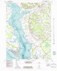
~ Rock Point MD topo map, 1:24000 scale, 7.5 X 7.5 Minute, Historical, 1943, updated 1983
Rock Point, Maryland, USGS topographic map dated 1943.
Includes geographic coordinates (latitude and longitude). This topographic map is suitable for hiking, camping, and exploring, or framing it as a wall map.
Printed on-demand using high resolution imagery, on heavy weight and acid free paper, or alternatively on a variety of synthetic materials.
Topos available on paper, Waterproof, Poly, or Tyvek. Usually shipping rolled, unless combined with other folded maps in one order.
- Product Number: USGS-5367150
- Free digital map download (high-resolution, GeoPDF): Rock Point, Maryland (file size: 14 MB)
- Map Size: please refer to the dimensions of the GeoPDF map above
- Weight (paper map): ca. 55 grams
- Map Type: POD USGS Topographic Map
- Map Series: HTMC
- Map Verison: Historical
- Cell ID: 38262
- Scan ID: 256801
- Imprint Year: 1983
- Woodland Tint: Yes
- Photo Revision Year: 1974
- Aerial Photo Year: 1974
- Edit Year: 1974
- Survey Year: 1943
- Datum: NAD27
- Map Projection: Polyconic
- Map published by United States Geological Survey
- Map Language: English
- Scanner Resolution: 600 dpi
- Map Cell Name: Rock Point
- Grid size: 7.5 X 7.5 Minute
- Date on map: 1943
- Map Scale: 1:24000
- Geographical region: Maryland, United States
Neighboring Maps:
All neighboring USGS topo maps are available for sale online at a variety of scales.
Spatial coverage:
Topo map Rock Point, Maryland, covers the geographical area associated the following places:
- Chaptico - Gravelly Hills - Blakistone - Hurry - Clover Dale Acres - Milestown - Barbers Quarter - Yellow Bank - Longview Beach - Indiantown - Woodberry Beach - Bull Run - Avenue - Lower Brambley (historical) - West Hatton - Maddox - Bushwood Wharf - Bushwood - Mill Point Shores - Rock Point - Ridgewood - Cobb Island - Denby Hill - Saint Catherine - Charleston Creek - Upper Brambley (historical)
- Map Area ID: AREA38.37538.25-76.875-76.75
- Northwest corner Lat/Long code: USGSNW38.375-76.875
- Northeast corner Lat/Long code: USGSNE38.375-76.75
- Southwest corner Lat/Long code: USGSSW38.25-76.875
- Southeast corner Lat/Long code: USGSSE38.25-76.75
- Northern map edge Latitude: 38.375
- Southern map edge Latitude: 38.25
- Western map edge Longitude: -76.875
- Eastern map edge Longitude: -76.75


