
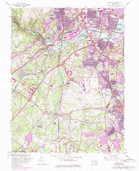
~ Relay MD topo map, 1:24000 scale, 7.5 X 7.5 Minute, Historical, 1957, updated 1984
Relay, Maryland, USGS topographic map dated 1957.
Includes geographic coordinates (latitude and longitude). This topographic map is suitable for hiking, camping, and exploring, or framing it as a wall map.
Printed on-demand using high resolution imagery, on heavy weight and acid free paper, or alternatively on a variety of synthetic materials.
Topos available on paper, Waterproof, Poly, or Tyvek. Usually shipping rolled, unless combined with other folded maps in one order.
- Product Number: USGS-5367100
- Free digital map download (high-resolution, GeoPDF): Relay, Maryland (file size: 16 MB)
- Map Size: please refer to the dimensions of the GeoPDF map above
- Weight (paper map): ca. 55 grams
- Map Type: POD USGS Topographic Map
- Map Series: HTMC
- Map Verison: Historical
- Cell ID: 37582
- Scan ID: 256775
- Imprint Year: 1984
- Woodland Tint: Yes
- Photo Revision Year: 1974
- Aerial Photo Year: 1974
- Field Check Year: 1957
- Survey Year: 1943
- Datum: NAD27
- Map Projection: Polyconic
- Map published by United States Geological Survey
- Map Language: English
- Scanner Resolution: 600 dpi
- Map Cell Name: Relay
- Grid size: 7.5 X 7.5 Minute
- Date on map: 1957
- Map Scale: 1:24000
- Geographical region: Maryland, United States
Neighboring Maps:
All neighboring USGS topo maps are available for sale online at a variety of scales.
Spatial coverage:
Topo map Relay, Maryland, covers the geographical area associated the following places:
- Provinces - Baltimore Highlands - Leeds - Capitol Mobile Park - Woods Edge - Terrace View Mobile Estates - Elkridge Heights - Shipley Corner - Spaulding Knolls - Rosemont - Mount Augustine - Foxhall Farm - Glen Burnie Heights - Crestwood - Severn Ridge - Rockburn Commons - Grove Ridge - Elkridge Mobile Home Park - The Peach Orchard - Stevenson Park - Stony Run - Monroe Gardens - Michaelton Manor - East Park Village - Ferndale - Monumental - English Consul - Timber Ridge - Harwood Park - Arundel Hills - Elmhurst Ridge - Patapsco - Ed Mar Trailer Park - Marble Hill - Twin Oaks - Relay - Oak Park - Parkwood - Munson Heights - Huntsmoor South - Montgomery Manor - Bentwoods - Lennox Park - Glenartney - Andorick Acres - Meade Village - Ridgeview - Sunnyfield Estates - Severn Woods - Raynor Heights - Hilton Place - Canbury Woods - Meadow Brook - Chesapeake Mobile Court - Severn Mobile Home Park - Orange Grove (historical) - Pleasantville - North Linthicum - Homeland Park - Saunders - Winans (historical) - Avalon - Woodlawn Heights - Terrace View Estates - Glen Cove Estates - Linthicum Heights - Woodside Square - Linthicum Hills - Garland Park - Wicklow Woods - Severn - McPherson - Timberview - South Gate - Harmans Woods - Lehigh - Severn Mills - Lynnbrook - Washington Crest Heights - The Provinces - Shipley Heights - Severn Village - Hunt Club Estates - Strawberry Hills - Burleytown - West Elkridge - Lawyers Hill - Montgomery Woods - Somerset - Garland - Osborne Heights - Glen Burnie Park - Halethorpe - Gapgalleon - Richardson Mews - Myers Estates - Willowdale - Sandalwood - Trevor Woods - Lake Village
- Map Area ID: AREA39.2539.125-76.75-76.625
- Northwest corner Lat/Long code: USGSNW39.25-76.75
- Northeast corner Lat/Long code: USGSNE39.25-76.625
- Southwest corner Lat/Long code: USGSSW39.125-76.75
- Southeast corner Lat/Long code: USGSSE39.125-76.625
- Northern map edge Latitude: 39.25
- Southern map edge Latitude: 39.125
- Western map edge Longitude: -76.75
- Eastern map edge Longitude: -76.625


