
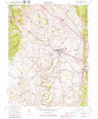
~ Middletown MD topo map, 1:24000 scale, 7.5 X 7.5 Minute, Historical, 1953, updated 1979
Middletown, Maryland, USGS topographic map dated 1953.
Includes geographic coordinates (latitude and longitude). This topographic map is suitable for hiking, camping, and exploring, or framing it as a wall map.
Printed on-demand using high resolution imagery, on heavy weight and acid free paper, or alternatively on a variety of synthetic materials.
Topos available on paper, Waterproof, Poly, or Tyvek. Usually shipping rolled, unless combined with other folded maps in one order.
- Product Number: USGS-5366768
- Free digital map download (high-resolution, GeoPDF): Middletown, Maryland (file size: 13 MB)
- Map Size: please refer to the dimensions of the GeoPDF map above
- Weight (paper map): ca. 55 grams
- Map Type: POD USGS Topographic Map
- Map Series: HTMC
- Map Verison: Historical
- Cell ID: 29125
- Scan ID: 256600
- Imprint Year: 1979
- Woodland Tint: Yes
- Photo Revision Year: 1979
- Aerial Photo Year: 1977
- Edit Year: 1979
- Datum: NAD27
- Map Projection: Polyconic
- Map published by United States Army Corps of Engineers
- Map Language: English
- Scanner Resolution: 600 dpi
- Map Cell Name: Middletown
- Grid size: 7.5 X 7.5 Minute
- Date on map: 1953
- Map Scale: 1:24000
- Geographical region: Maryland, United States
Neighboring Maps:
All neighboring USGS topo maps are available for sale online at a variety of scales.
Spatial coverage:
Topo map Middletown, Maryland, covers the geographical area associated the following places:
- Coblentz Heights - Edinburg Forest - Arnoldtown - Middletown View - Cowell - Minnick - Beachley - Colebrook - Valley Overlook - Wiles Estates - Waynes Way - Bolivar Heights - Morningside - Arch Bridge - Hollow Estates - Glenridge Estates - Holter - Homers Delight - Harmony Knolls - Zittlestown - West Middletown Estates - Bolivar - Remsberg Acres - Brandenburg Estates - Der Spring Farms - Brookridge North - Braddock Estates - Picnic Woods Estates - Sunset View - Hawbottom - Skyline Gardens - Corner House - Foxfield Middletown - Horman - Middletown South - Bidle Hill Acres - Skyline Estates - Middletown - Valley View Estates - Spoolsville - Crest Manor Estates - Middletown Manor - Somerset - Gambrill South - Braddock Heights - Cross Hollow - Glenoble - Kelview - Hawbottom Heights - Catoctin Hills - Woodcrest - Valley Heights - Middletown Valley Estates - Broad Run Acres - Harshman Estates - Moser - Springdale - Lockwood Heights - Frostown - Bellemonte - Middletown Heights - Catoctin Acres - Summers - Station Roads - Strawleigh - Countryside West - Oak Park - Fountaindale South - Ridge Crest Estates - Broad Run - Harmony - Hollow Road Estates - Fountain Dale - North Jefferson - Westchester
- Map Area ID: AREA39.539.375-77.625-77.5
- Northwest corner Lat/Long code: USGSNW39.5-77.625
- Northeast corner Lat/Long code: USGSNE39.5-77.5
- Southwest corner Lat/Long code: USGSSW39.375-77.625
- Southeast corner Lat/Long code: USGSSE39.375-77.5
- Northern map edge Latitude: 39.5
- Southern map edge Latitude: 39.375
- Western map edge Longitude: -77.625
- Eastern map edge Longitude: -77.5


