
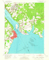
~ Havre De Grace MD topo map, 1:24000 scale, 7.5 X 7.5 Minute, Historical, 1953, updated 1965
Havre De Grace, Maryland, USGS topographic map dated 1953.
Includes geographic coordinates (latitude and longitude). This topographic map is suitable for hiking, camping, and exploring, or framing it as a wall map.
Printed on-demand using high resolution imagery, on heavy weight and acid free paper, or alternatively on a variety of synthetic materials.
Topos available on paper, Waterproof, Poly, or Tyvek. Usually shipping rolled, unless combined with other folded maps in one order.
- Product Number: USGS-5366434
- Free digital map download (high-resolution, GeoPDF): Havre De Grace, Maryland (file size: 10 MB)
- Map Size: please refer to the dimensions of the GeoPDF map above
- Weight (paper map): ca. 55 grams
- Map Type: POD USGS Topographic Map
- Map Series: HTMC
- Map Verison: Historical
- Cell ID: 19698
- Scan ID: 256422
- Imprint Year: 1965
- Woodland Tint: Yes
- Aerial Photo Year: 1952
- Edit Year: 1953
- Survey Year: 1940
- Datum: NAD27
- Map Projection: Polyconic
- Map published by United States Geological Survey
- Map Language: English
- Scanner Resolution: 600 dpi
- Map Cell Name: Havre De Grace
- Grid size: 7.5 X 7.5 Minute
- Date on map: 1953
- Map Scale: 1:24000
- Geographical region: Maryland, United States
Neighboring Maps:
All neighboring USGS topo maps are available for sale online at a variety of scales.
Spatial coverage:
Topo map Havre De Grace, Maryland, covers the geographical area associated the following places:
- Homestead Mobile Home Estates - Havre de Grace - Sunnyside - Chestnut Point - Meadowvale Manor - Meadowvale - Shawnee Brook South - Mountain Hill - Minnick - Manor Heights - Oakington - Greenbank Farms - Running Brook Park - Grace Harbour - Port Deposit - Craigtown - Misty Meadows - Aikin - Bayview Estates - Carpenter Point - Chestnut Point Estates - Perryville - Jackson - Foys Hill (historical) - Osborne - Belvedere - Highland Park - Frenchtown - Blythedale - Poplar Point - Rock Run - Arrowhead Acres - Robin Acres - Concord - Havre de Grace Heights - Principio Furnace - Chesapeake Landing - Perry Point
- Map Area ID: AREA39.62539.5-76.125-76
- Northwest corner Lat/Long code: USGSNW39.625-76.125
- Northeast corner Lat/Long code: USGSNE39.625-76
- Southwest corner Lat/Long code: USGSSW39.5-76.125
- Southeast corner Lat/Long code: USGSSE39.5-76
- Northern map edge Latitude: 39.625
- Southern map edge Latitude: 39.5
- Western map edge Longitude: -76.125
- Eastern map edge Longitude: -76


