
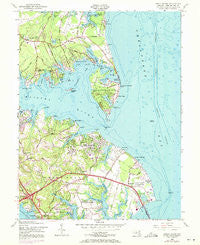
~ Gibson Island MD topo map, 1:24000 scale, 7.5 X 7.5 Minute, Historical, 1954, updated 1971
Gibson Island, Maryland, USGS topographic map dated 1954.
Includes geographic coordinates (latitude and longitude). This topographic map is suitable for hiking, camping, and exploring, or framing it as a wall map.
Printed on-demand using high resolution imagery, on heavy weight and acid free paper, or alternatively on a variety of synthetic materials.
Topos available on paper, Waterproof, Poly, or Tyvek. Usually shipping rolled, unless combined with other folded maps in one order.
- Product Number: USGS-5366334
- Free digital map download (high-resolution, GeoPDF): Gibson Island, Maryland (file size: 16 MB)
- Map Size: please refer to the dimensions of the GeoPDF map above
- Weight (paper map): ca. 55 grams
- Map Type: POD USGS Topographic Map
- Map Series: HTMC
- Map Verison: Historical
- Cell ID: 17177
- Scan ID: 256368
- Imprint Year: 1971
- Woodland Tint: Yes
- Photo Revision Year: 1970
- Aerial Photo Year: 1970
- Survey Year: 1943
- Datum: NAD27
- Map Projection: Polyconic
- Map published by United States Army Corps of Engineers
- Map Language: English
- Scanner Resolution: 600 dpi
- Map Cell Name: Gibson Island
- Grid size: 7.5 X 7.5 Minute
- Date on map: 1954
- Map Scale: 1:24000
- Geographical region: Maryland, United States
Neighboring Maps:
All neighboring USGS topo maps are available for sale online at a variety of scales.
Spatial coverage:
Topo map Gibson Island, Maryland, covers the geographical area associated the following places:
- Colonial Manor Trailer Park - Riding Woods - Arcadia - Admirals Walk - Point-O-Woods - Atlantis - Ulmstead Cove - Oakmont - Dorado Hills - Captains Choice - Podickory Point - Saint Margarets - Meredith Homes - Cedarwood Cove - Mount Carmel - Saint Johns Woods - Capetowne - Bayhead - Tydings on the Bay - Bay Hills - Old Mill Bottom Estates - Pinehurst - Milburn on the Magothy - Deer Creek - Pleasant Plains - Ulmstead Acres - Cherrywood - Whitehall Estates - Great Meadows - Landhaven - Sylvan View - Long Point - Walnut Ridge - Gibson Island - Foxmoor - Greenholly - Saint Margarets Farm - Oakland Hill - Sturbridge - Holly Anna Acres - Tree Tops - Cape Saint Claire - Kimberly Woods Village - Windermere Estates - Hidden Ridge - Skidmore - Bayberry - Lyndale - Manresa - Browns Woods - Green Gables - Sillery Bay Forest - Winchester - Ulmstead Point - Ventnor - Whispering Woods - Saybrooke - Fairwood - Lynwood Village - Whitehall Beach - Herons Watch - Woods Landing - Tanglewood - Forest Meadows - Mountain Wood - Stonington - Ulmstead Estates - Long Point on the Magothy - Henekes Corner - North Shore - The Meadows - Shirleyville - Hollyberry Woods - Northport - Ulmstead Gardens - Bellerive Village - Severnside - Bell Forest - Broadwater Beach - Shore Acres - Pettebone Farms - Lake Shore - Pinehurst on the Bodkin - Eagle Hill - Dulls Corner - Hunters Harbor - Dorado Village - Boulevard Park - Revell Downs - Longview - Martins Cove Farm - Sillman Estates - Kingston Estates - Briar Lea - Browns Woods Villa - Brice Manor - Sillery Bay - Beacon View - Briarwood - Whitehall Manor
- Map Area ID: AREA39.12539-76.5-76.375
- Northwest corner Lat/Long code: USGSNW39.125-76.5
- Northeast corner Lat/Long code: USGSNE39.125-76.375
- Southwest corner Lat/Long code: USGSSW39-76.5
- Southeast corner Lat/Long code: USGSSE39-76.375
- Northern map edge Latitude: 39.125
- Southern map edge Latitude: 39
- Western map edge Longitude: -76.5
- Eastern map edge Longitude: -76.375


