
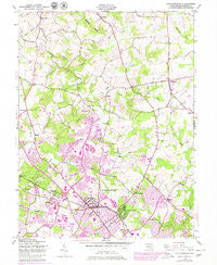
~ Gaithersburg MD topo map, 1:24000 scale, 7.5 X 7.5 Minute, Historical, 1945, updated 1979
Gaithersburg, Maryland, USGS topographic map dated 1945.
Includes geographic coordinates (latitude and longitude). This topographic map is suitable for hiking, camping, and exploring, or framing it as a wall map.
Printed on-demand using high resolution imagery, on heavy weight and acid free paper, or alternatively on a variety of synthetic materials.
Topos available on paper, Waterproof, Poly, or Tyvek. Usually shipping rolled, unless combined with other folded maps in one order.
- Product Number: USGS-5366310
- Free digital map download (high-resolution, GeoPDF): Gaithersburg, Maryland (file size: 12 MB)
- Map Size: please refer to the dimensions of the GeoPDF map above
- Weight (paper map): ca. 55 grams
- Map Type: POD USGS Topographic Map
- Map Series: HTMC
- Map Verison: Historical
- Cell ID: 16654
- Scan ID: 256355
- Imprint Year: 1979
- Woodland Tint: Yes
- Photo Revision Year: 1979
- Aerial Photo Year: 1977
- Edit Year: 1979
- Field Check Year: 1945
- Datum: NAD27
- Map Projection: Polyconic
- Map published by United States Army Corps of Engineers
- Map Language: English
- Scanner Resolution: 600 dpi
- Map Cell Name: Gaithersburg
- Grid size: 7.5 X 7.5 Minute
- Date on map: 1945
- Map Scale: 1:24000
- Geographical region: Maryland, United States
Neighboring Maps:
All neighboring USGS topo maps are available for sale online at a variety of scales.
Spatial coverage:
Topo map Gaithersburg, Maryland, covers the geographical area associated the following places:
- Bridlewood - Middlebrook - Seneca Park - Plumgar - Diamond Farms - Chadswood - Brink - Brandermill - Barton Woods - Walnut Hill - Hamlet North - Flower Hill - West Riding - Candlewood Park - Longdraft - Brooke Grove - Cashell Estates - Middlebrook Hills - Londonderry - Foxlair Acres - Montgomery Village - Laytonsville Knolls - Watkins Overlook - Burnham Woods - Winters Run - Clopper - Goshen - Freedom Forest - Fox Chapel - Goshen Hunt Hills - Cedar Grove - Orchard Pond - Hadley Farms - Goshen Hunt Estates - Fetrows - Burnham Hills - Longview South - Neelsville - Montgomery Meadows - Metropolitan Grove - Emory Grove - Hickory Grove - Ridges of Stedwick - Coventry - Edinburgh - The Plantations - Gaithersburg - Golf Estates - Cider Barrel Motor Home Court (historical) - Seneca Upland - Brook Hollow - Banner Country - Frenchton Place - Schneiders Trailer Haven - Parkridge Estates - Blount Commons - Oakmont Manor - Whetstone - Relda Square - Charlene - Rocky Road Park - Redland - Garfield Manor - Wexford - Walkers Choice - Pleasant Run - Parkridge - Brown - The Elms at Germantown - Ridgecrest - Quail Valley - Nathans Hill - Laytonsville - Quail Ridge - Henderson Corner - Milestone - Rosemont - Brinkwood Estates - Prathertown - Woodfield - Orchard Place - Brink Meadow - Watkins Mill - Fernshire Woods - Dorsey Estates - Washington Grove - Kings Square - Wilderness Walk - Middlebrook Mobile Home Park - Bennington - Log Town (historical) - Rosewood Estates - Windbrook - Wildcat Forest - Layton Ridge - Ward Farm Estates - Observatory Heights - Fernshire Farms - Stewart Town
- Map Area ID: AREA39.2539.125-77.25-77.125
- Northwest corner Lat/Long code: USGSNW39.25-77.25
- Northeast corner Lat/Long code: USGSNE39.25-77.125
- Southwest corner Lat/Long code: USGSSW39.125-77.25
- Southeast corner Lat/Long code: USGSSE39.125-77.125
- Northern map edge Latitude: 39.25
- Southern map edge Latitude: 39.125
- Western map edge Longitude: -77.25
- Eastern map edge Longitude: -77.125


