
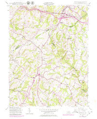
~ Damascus MD topo map, 1:24000 scale, 7.5 X 7.5 Minute, Historical, 1944, updated 1979
Damascus, Maryland, USGS topographic map dated 1944.
Includes geographic coordinates (latitude and longitude). This topographic map is suitable for hiking, camping, and exploring, or framing it as a wall map.
Printed on-demand using high resolution imagery, on heavy weight and acid free paper, or alternatively on a variety of synthetic materials.
Topos available on paper, Waterproof, Poly, or Tyvek. Usually shipping rolled, unless combined with other folded maps in one order.
- Product Number: USGS-5366076
- Free digital map download (high-resolution, GeoPDF): Damascus, Maryland (file size: 12 MB)
- Map Size: please refer to the dimensions of the GeoPDF map above
- Weight (paper map): ca. 55 grams
- Map Type: POD USGS Topographic Map
- Map Series: HTMC
- Map Verison: Historical
- Cell ID: 11269
- Scan ID: 256226
- Imprint Year: 1979
- Woodland Tint: Yes
- Photo Revision Year: 1979
- Aerial Photo Year: 1977
- Edit Year: 1979
- Field Check Year: 1944
- Datum: NAD27
- Map Projection: Polyconic
- Map published by United States Army Corps of Engineers
- Map Language: English
- Scanner Resolution: 600 dpi
- Map Cell Name: Damascus
- Grid size: 7.5 X 7.5 Minute
- Date on map: 1944
- Map Scale: 1:24000
- Geographical region: Maryland, United States
Neighboring Maps:
All neighboring USGS topo maps are available for sale online at a variety of scales.
Spatial coverage:
Topo map Damascus, Maryland, covers the geographical area associated the following places:
- Hickory Hill - Village of Tall Oaks - Dendor Mar Estates - Merridale Gardens - Park View Estates - Wolf Den Spring - Merridale - Southview - Davis - Stonelake - Silver Crest - Mid Country View - Damascus Terrace - Smith Village - Rattle Ridge - Bartholows - Bootjack - Damascus - Four County Farm - Sundown Manor - Sugarloaf Overlook - Seneca Springs - Damascus Manor - Claggettsville - Hungerford Manor - Damascus Valley Park - Friendship Knolls - Hanford Estates - Damascus Gardens - Pheasant Ridge Estates - Molesworth Hills - Highview - Diamond View - Florence Estates - Parrsville - Harmony Hall - Poulsen Heights - Cedar Grove Knolls - Spring Garden Estates - Rosswood Estates - Treasure Mountain - East Rolling Hills - Linganore View - Silver Maple Estates - Pheasant Ridge Mobile Estates - Skyline Manor - Bradford Estates - Friendship - Bennett Manor - Hawthorne Acres - Farmfield Estates - Sweepstakes - Purdum - Ridgeville - Samhill Estates - Ashley Acres - Shaffers Mill Estates - Janwood - Kings Valley Manor - Mill Bottom - Long Corner - Duvall Manor - Fremont Acres - Upper Seneca Crest - Tolley Terrace - Langdon Woods - Country View - Fox Ridge Estates - Harvest Ridge - Conestoga Heights - Kings Valley - Etchison - Mount Radnor Heights - Annapolis Rock - Mullinix - Kingstead Knolls - Chesney - Rolling Hills - Kemptown - West Oak Fields - Clearspring Manor - Seneca Overlook - Cedar Heights - Park Lake Estates - Mount Lebanon - Skyline Woods - Kittyhawk Estates - Damascus Valley Estates - County View - Hickory Ridge - Kelly Ridge - Cedar Heights Estates - Bicentennial Estates - Damascus Hill - Ronalee Hills - Browningsville - Greenhills - Damascus View
- Map Area ID: AREA39.37539.25-77.25-77.125
- Northwest corner Lat/Long code: USGSNW39.375-77.25
- Northeast corner Lat/Long code: USGSNE39.375-77.125
- Southwest corner Lat/Long code: USGSSW39.25-77.25
- Southeast corner Lat/Long code: USGSSE39.25-77.125
- Northern map edge Latitude: 39.375
- Southern map edge Latitude: 39.25
- Western map edge Longitude: -77.25
- Eastern map edge Longitude: -77.125


