
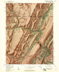
~ Cumberland MD topo map, 1:24000 scale, 7.5 X 7.5 Minute, Historical, 1949, updated 1961
Cumberland, Maryland, USGS topographic map dated 1949.
Includes geographic coordinates (latitude and longitude). This topographic map is suitable for hiking, camping, and exploring, or framing it as a wall map.
Printed on-demand using high resolution imagery, on heavy weight and acid free paper, or alternatively on a variety of synthetic materials.
Topos available on paper, Waterproof, Poly, or Tyvek. Usually shipping rolled, unless combined with other folded maps in one order.
- Product Number: USGS-5366042
- Free digital map download (high-resolution, GeoPDF): Cumberland, Maryland (file size: 22 MB)
- Map Size: please refer to the dimensions of the GeoPDF map above
- Weight (paper map): ca. 55 grams
- Map Type: POD USGS Topographic Map
- Map Series: HTMC
- Map Verison: Historical
- Cell ID: 11006
- Scan ID: 256208
- Imprint Year: 1961
- Aerial Photo Year: 1947
- Field Check Year: 1949
- Datum: NAD27
- Map Projection: Polyconic
- Shaded Relief map: Yes
- Map published by United States Geological Survey
- Map Language: English
- Scanner Resolution: 600 dpi
- Map Cell Name: Cumberland
- Grid size: 7.5 X 7.5 Minute
- Date on map: 1949
- Map Scale: 1:24000
- Geographical region: Maryland, United States
Neighboring Maps:
All neighboring USGS topo maps are available for sale online at a variety of scales.
Spatial coverage:
Topo map Cumberland, Maryland, covers the geographical area associated the following places:
- Corriganville - Winchester - South Cumberland - Ellerslie - Homewood - Cumberland Heights - Sixmile House - Wellersburg - Narrows Park - La Vale - Carpendale - Ridgeley - Locust Grove - Lap - Red Hill - Lucas Heights - Eckhart Junction - Knobmount - Georges Creek - Shanty Town (historical) - Mount Savage Junction - Cumberland - State Line - Barrelville - Kreigbaum - Roberts - Allegany Grove
- Map Area ID: AREA39.7539.625-78.875-78.75
- Northwest corner Lat/Long code: USGSNW39.75-78.875
- Northeast corner Lat/Long code: USGSNE39.75-78.75
- Southwest corner Lat/Long code: USGSSW39.625-78.875
- Southeast corner Lat/Long code: USGSSE39.625-78.75
- Northern map edge Latitude: 39.75
- Southern map edge Latitude: 39.625
- Western map edge Longitude: -78.875
- Eastern map edge Longitude: -78.75


