
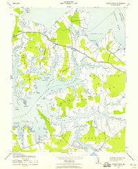
~ Church Creek MD topo map, 1:24000 scale, 7.5 X 7.5 Minute, Historical, 1942, updated 1958
Church Creek, Maryland, USGS topographic map dated 1942.
Includes geographic coordinates (latitude and longitude). This topographic map is suitable for hiking, camping, and exploring, or framing it as a wall map.
Printed on-demand using high resolution imagery, on heavy weight and acid free paper, or alternatively on a variety of synthetic materials.
Topos available on paper, Waterproof, Poly, or Tyvek. Usually shipping rolled, unless combined with other folded maps in one order.
- Product Number: USGS-5365954
- Free digital map download (high-resolution, GeoPDF): Church Creek, Maryland (file size: 7 MB)
- Map Size: please refer to the dimensions of the GeoPDF map above
- Weight (paper map): ca. 55 grams
- Map Type: POD USGS Topographic Map
- Map Series: HTMC
- Map Verison: Historical
- Cell ID: 8721
- Scan ID: 256162
- Imprint Year: 1958
- Woodland Tint: Yes
- Survey Year: 1942
- Datum: NAD27
- Map Projection: Polyconic
- Map published by United States Army Corps of Engineers
- Map published by United States Department of War
- Map Language: English
- Scanner Resolution: 600 dpi
- Map Cell Name: Church Creek
- Grid size: 7.5 X 7.5 Minute
- Date on map: 1942
- Map Scale: 1:24000
- Geographical region: Maryland, United States
Neighboring Maps:
All neighboring USGS topo maps are available for sale online at a variety of scales.
Spatial coverage:
Topo map Church Creek, Maryland, covers the geographical area associated the following places:
- Snug Harbor Estates - Ripling Waters - Brelsmir Haven - Dailsville - Kilmaurie - Cornersville - Wrights - Hudson Creek - Riverton - Madison - Brad Vern Park - Paw Paw Acres - Seawilde - Lloyds - Deep Harbor Estates - Woolford - Town Point Estates - Paw Paw Point - Hills Point - Ross Acres - Church Creek
- Map Area ID: AREA38.62538.5-76.25-76.125
- Northwest corner Lat/Long code: USGSNW38.625-76.25
- Northeast corner Lat/Long code: USGSNE38.625-76.125
- Southwest corner Lat/Long code: USGSSW38.5-76.25
- Southeast corner Lat/Long code: USGSSE38.5-76.125
- Northern map edge Latitude: 38.625
- Southern map edge Latitude: 38.5
- Western map edge Longitude: -76.25
- Eastern map edge Longitude: -76.125


