
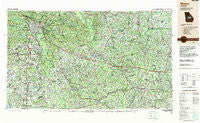
~ Macon GA topo map, 1:250000 scale, 1 X 2 Degree, Historical, 1988, updated 1989
Macon, Georgia, USGS topographic map dated 1988.
Includes geographic coordinates (latitude and longitude). This topographic map is suitable for hiking, camping, and exploring, or framing it as a wall map.
Printed on-demand using high resolution imagery, on heavy weight and acid free paper, or alternatively on a variety of synthetic materials.
Topos available on paper, Waterproof, Poly, or Tyvek. Usually shipping rolled, unless combined with other folded maps in one order.
- Product Number: USGS-5365366
- Free digital map download (high-resolution, GeoPDF): Macon, Georgia (file size: 27 MB)
- Map Size: please refer to the dimensions of the GeoPDF map above
- Weight (paper map): ca. 55 grams
- Map Type: POD USGS Topographic Map
- Map Series: HTMC
- Map Verison: Historical
- Cell ID: 68886
- Scan ID: 247836
- Imprint Year: 1989
- Woodland Tint: Yes
- Aerial Photo Year: 1982
- Edit Year: 1988
- Datum: NAD27
- Map Projection: Universal Transverse Mercator
- Map published by United States Geological Survey
- Map Language: English
- Scanner Resolution: 600 dpi
- Map Cell Name: Macon
- Grid size: 1 X 2 Degree
- Date on map: 1988
- Map Scale: 1:250000
- Geographical region: Georgia, United States
Neighboring Maps:
All neighboring USGS topo maps are available for sale online at a variety of scales.
Spatial coverage:
Topo map Macon, Georgia, covers the geographical area associated the following places:
- Davisboro - Rutland - Bedingfield - Crystal Springs - Tippettville - Green Meadows - Barnhill - Sonja Heights - Beaveroaks - Canoe - Lanier Heights - Gresston - Clayfields - Hatoff (historical) - Ceres - Keenes Crossing (historical) - Pike Acres - Cox (historical) - Sanders - Nunez - Riverside Hills - Four Points - Klondike - Stevens Crossing - Blun - Helena - Grogan - Miami Valley - Kings Cove - Dublin - Hayneville - Blackville - Center - Westgate Estates - Powersville - Vienna - Bristol Forest - Petross - Clarkview - Irwinton - Hebron - North Forest Hills - Morningside - Cooktown - The Heather on Houston Lake - Uvalda - Hazard - Washington Square - Forest Pointe - Sunnydale Acres - Alligood - Birdsville - Elmdale Estates - Henderson - Danville - Bales (historical) - Oconee - Bullard - Holly Bluff - Gary - Waverly Place - Frazier - Brewton - Creekside - Vonreg Subdivision - Pineview - Lizella - Midville - Jeffersonville - Redding - Arlington Park - North Highlands - Milan - Magruder - Glen Cove - Riddleville - Unadilla - Stillmore - Bloomfield Estates - Woodard Estates - Ponderosa Lake - Sigurd (historical) - Emerich - Sleepy Hollow - Bryn Mawr - Erick - Honey Ridge Plantation - Cochran - Hartley - Richardson Estates - Empire - Van Buren (historical) - Centerville - McCranie - Old Town - James - Cunningham Corner - Musgrove (historical) - Shewmake - Highland Circle
- Map Area ID: AREA3332-84-82
- Northwest corner Lat/Long code: USGSNW33-84
- Northeast corner Lat/Long code: USGSNE33-82
- Southwest corner Lat/Long code: USGSSW32-84
- Southeast corner Lat/Long code: USGSSE32-82
- Northern map edge Latitude: 33
- Southern map edge Latitude: 32
- Western map edge Longitude: -84
- Eastern map edge Longitude: -82


