
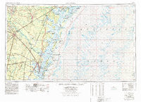
~ Brunswick GA topo map, 1:250000 scale, 1 X 2 Degree, Historical, 1978
Brunswick, Georgia, USGS topographic map dated 1978.
Includes geographic coordinates (latitude and longitude). This topographic map is suitable for hiking, camping, and exploring, or framing it as a wall map.
Printed on-demand using high resolution imagery, on heavy weight and acid free paper, or alternatively on a variety of synthetic materials.
Topos available on paper, Waterproof, Poly, or Tyvek. Usually shipping rolled, unless combined with other folded maps in one order.
- Product Number: USGS-5365360
- Free digital map download (high-resolution, GeoPDF): Brunswick, Georgia (file size: 17 MB)
- Map Size: please refer to the dimensions of the GeoPDF map above
- Weight (paper map): ca. 55 grams
- Map Type: POD USGS Topographic Map
- Map Series: HTMC
- Map Verison: Historical
- Cell ID: 68694
- Scan ID: 247835
- Woodland Tint: Yes
- Visual Version Number: 2
- Aerial Photo Year: 1976
- Edit Year: 1977
- Field Check Year: 1956
- Datum: Unstated
- Map Projection: Transverse Mercator
- Map published by United States Geological Survey
- Map Language: English
- Scanner Resolution: 600 dpi
- Map Cell Name: Brunswick
- Grid size: 1 X 2 Degree
- Date on map: 1978
- Map Scale: 1:250000
- Geographical region: Georgia, United States
Neighboring Maps:
All neighboring USGS topo maps are available for sale online at a variety of scales.
Spatial coverage:
Topo map Brunswick, Georgia, covers the geographical area associated the following places:
- Cedar Hammock - Wilmington Park - Savannah Beach - Screven Fork - Cox - Clover Heights - Roderick (historical) - Georgetown - Grove Point - Townsend - Fleming - Live Oak Mobile Home Village - Ridgewood Plantation - Happy Landing - Fendig - Windward - Brunswick Villa - Martins (historical) - Thalmann - Berkshire Woods - Lida (historical) - Cinder Hill - Jewtown - Youngwood - Glynco Annex - Atkinson - Raccoon Bluff - Kent (historical) - Lecount - Trudie - Oak Level - Waverly - Bradwell Estates - Chippewa Terrace - Ashmore - Saint Simons Heights - Myrtle Grove - Glendale Gardens - Cox - Burroughs - Saint Simons - Jenks (historical) - Hayner - Waverly Pines Park - Harrock Hall - Piney Grove Mobile Home Park - Middle Place - Dunham (historical) - Wildwood - Village Green - Gum Branch - Southern Pines Mobile Home Village - Hickory Bluff - Deer Run Estates - Mosely Mobile Home Park - Smiley (historical) - Wesley Oaks - Wilshire - Marshwood at the Landings - North End - Pipkin Mobile Home Park - Salter Mobile Home Park - Keller - Big Oak - Epworth Acres - Carnigan - Pinehurst - Ellis Point - Country Manor Mobile Home Park - Kicklighter (historical) - Satilla Shores - Dover Bluff - Drum Point Landing - Saint Simon Mills - Suburban Estates - Nahunta - Herbert Heights - Azalea Gardens - Strain (historical) - Seabrook - Sapelo Island - Bethel (historical) - Burton Terrace - Fairhope - Pine Harbor - Burnside - Devenwood - Mount Pleasant - Vernonburg - Tarboro - New Hope - El Dorado - Williamsburg Manor - Montgomery - Georgetown - Oglethorpe Manor - Thornhill Mobile Home Park - Oak Bluff - Kensington Park - Grimball Park
- Map Area ID: AREA3231-82-80
- Northwest corner Lat/Long code: USGSNW32-82
- Northeast corner Lat/Long code: USGSNE32-80
- Southwest corner Lat/Long code: USGSSW31-82
- Southeast corner Lat/Long code: USGSSE31-80
- Northern map edge Latitude: 32
- Southern map edge Latitude: 31
- Western map edge Longitude: -82
- Eastern map edge Longitude: -80


