
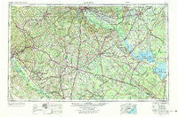
~ Augusta GA topo map, 1:250000 scale, 1 X 2 Degree, Historical, 1957, updated 1984
Augusta, Georgia, USGS topographic map dated 1957.
Includes geographic coordinates (latitude and longitude). This topographic map is suitable for hiking, camping, and exploring, or framing it as a wall map.
Printed on-demand using high resolution imagery, on heavy weight and acid free paper, or alternatively on a variety of synthetic materials.
Topos available on paper, Waterproof, Poly, or Tyvek. Usually shipping rolled, unless combined with other folded maps in one order.
- Product Number: USGS-5365350
- Free digital map download (high-resolution, GeoPDF): Augusta, Georgia (file size: 22 MB)
- Map Size: please refer to the dimensions of the GeoPDF map above
- Weight (paper map): ca. 55 grams
- Map Type: POD USGS Topographic Map
- Map Series: HTMC
- Map Verison: Historical
- Cell ID: 68654
- Scan ID: 247830
- Imprint Year: 1984
- Woodland Tint: Yes
- Aerial Photo Year: 1955
- Edit Year: 1969
- Field Check Year: 1957
- Datum: Unstated
- Map Projection: Transverse Mercator
- Map published by United States Geological Survey
- Map Language: English
- Scanner Resolution: 600 dpi
- Map Cell Name: Augusta
- Grid size: 1 X 2 Degree
- Date on map: 1957
- Map Scale: 1:250000
- Geographical region: Georgia, United States
Neighboring Maps:
All neighboring USGS topo maps are available for sale online at a variety of scales.
Spatial coverage:
Topo map Augusta, Georgia, covers the geographical area associated the following places:
- Hampton Trace - Sheridan Estates - Mount Beulah - Honeywood - Shephard Park - Hilda - Woodside Manor - Trenton - Davis Station - Marshall Heights - Summers Homes - Speigner - Black Creek - Ashleigh - Sunny Brook - Leawood - Foxtown - Azalea Trailer Park - Marden Ranchettes - Red Bank - Weston - Woodridge - Hollywood - Windsor City Mobile Home Park - Sumter - Balltown - Cedarwood - The Colony - Arthurtown - Westcliff Estates - Yenome - Lykes - Rimini - Dominion Hills - Richwood - Azalea Estates - Orangeburg Manor - Turrin Hill - Hearthstone - Aiken Estates - Shuler (historical) - Dixie Circle - Forest Heights - Crystal View - Geddie Gardens - Heritage Hills - Wrenwood - Gregg Park - Gravel Hill - Reevesville - Bloomville - Black Tom (historical) - Hughes - Old Saint George - Midfield - Woodhill Estates - Wilkinson Heights - Nelson Hill - Pinecrest - Martin Subdivision - Montmorenci - Ascaga Heights - Sardinia - Quicktown - Augusta - Huets Crossroads - Little Belvidere - Rodgers - Bonniview Estates - Clearwater - Adams Landing - Weeks Landing - Cotton Hill - Finland - Stilton - Harmon Estates - Coventry - Mealing Heights - Brady Heights - Browns Landing - Brierfield - Sandy Run - Felderville - Sanders Subdivision - Summer View - Eagle Point - Ulmer - Horse Creek - Pleasant Lane - Club Forest - Ott (historical) - Church Hill (historical) - Allendale - Bluff Estates - Huntington Estates - Crosland Park - New Ellenton - Brick Yard Trace - Bouknight - Greenbriar
- Map Area ID: AREA3433-82-80
- Northwest corner Lat/Long code: USGSNW34-82
- Northeast corner Lat/Long code: USGSNE34-80
- Southwest corner Lat/Long code: USGSSW33-82
- Southeast corner Lat/Long code: USGSSE33-80
- Northern map edge Latitude: 34
- Southern map edge Latitude: 33
- Western map edge Longitude: -82
- Eastern map edge Longitude: -80


