
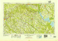
~ Augusta GA topo map, 1:250000 scale, 1 X 2 Degree, Historical, 1954, updated 1954
Augusta, Georgia, USGS topographic map dated 1954.
Includes geographic coordinates (latitude and longitude). This topographic map is suitable for hiking, camping, and exploring, or framing it as a wall map.
Printed on-demand using high resolution imagery, on heavy weight and acid free paper, or alternatively on a variety of synthetic materials.
Topos available on paper, Waterproof, Poly, or Tyvek. Usually shipping rolled, unless combined with other folded maps in one order.
- Product Number: USGS-5365342
- Free digital map download (high-resolution, GeoPDF): Augusta, Georgia (file size: 20 MB)
- Map Size: please refer to the dimensions of the GeoPDF map above
- Weight (paper map): ca. 55 grams
- Map Type: POD USGS Topographic Map
- Map Series: HTMC
- Map Verison: Historical
- Cell ID: 68654
- Scan ID: 247826
- Imprint Year: 1954
- Woodland Tint: Yes
- Aerial Photo Year: 1945
- Datum: Unstated
- Map Projection: Transverse Mercator
- Map published by United States Army Corps of Engineers
- Map published by United States Army
- Map Language: English
- Scanner Resolution: 600 dpi
- Map Cell Name: Augusta
- Grid size: 1 X 2 Degree
- Date on map: 1954
- Map Scale: 1:250000
- Geographical region: Georgia, United States
Neighboring Maps:
All neighboring USGS topo maps are available for sale online at a variety of scales.
Spatial coverage:
Topo map Augusta, Georgia, covers the geographical area associated the following places:
- Mayesville East Subdivision - Charlestowne - Shiloh - Canaan - Heatherwood - Beech Island - Clemson Terrace - Carolina Gardens - Williams - Dorange - Midway - Swearingen (historical) - Oaks Crossroads - Storm Branch Park - Strawberry - Forest Heights - Holly Ridge - Jamison - Plunket (historical) - Trinity Cross Roads - Gailmoor - Lake Forest Estates - Crafton (historical) - Swinton - Johnsville - Harrisburg - Crestdale - Congaree Gardens - Pringletown - Giant - Mealing Heights - Wedgefield - Camburg Acres - Scoville Woods - Springtown - Eureka - Gerwil Acres - Warwick Estates - Lafayette Heights - Summers Homes - Red Bank (historical) - Woodland Heights - Seaton - Wing Road - Waring Hall - Milford - Camp Rawls - Lees - Locklair (historical) - Dalby Downs - Groomville - Owens Crossroad - Jacksonville - Forest Lake Estates - Mount Holly - Hancock Landing - Southgate - Jennys - Moss Heights - Heatherwood - Marshall Heights - Pine Hill - Weeks Landing - Harmony - Cedarwood - Guignard Park East - James Crossroads - Shephard Park - Paxville - Orangeburg Manor - Shiloh Heights - Murraysville - Stratford Forest - Oakridge - Colonial Heights - Westcliff - East Sumter - Starmount - Croft - Woodland - Hamburg - Hillavista - Green Acres - Elloree - Springbank Hills - Lotts Crossroads - Camp Gravatt - Sims - Silver Bluff Estates - Rosemary (historical) - Bath - Pine Forest - Cross Cross Roads - Meadowfield - Greenfield - Singleton - Windsor City Mobile Home Park - Warrenville - Kalmia Landing - Foxtown
- Map Area ID: AREA3433-82-80
- Northwest corner Lat/Long code: USGSNW34-82
- Northeast corner Lat/Long code: USGSNE34-80
- Southwest corner Lat/Long code: USGSSW33-82
- Southeast corner Lat/Long code: USGSSE33-80
- Northern map edge Latitude: 34
- Southern map edge Latitude: 33
- Western map edge Longitude: -82
- Eastern map edge Longitude: -80


