
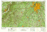
~ Atlanta GA topo map, 1:250000 scale, 1 X 2 Degree, Historical, 1953, updated 1973
Atlanta, Georgia, USGS topographic map dated 1953.
Includes geographic coordinates (latitude and longitude). This topographic map is suitable for hiking, camping, and exploring, or framing it as a wall map.
Printed on-demand using high resolution imagery, on heavy weight and acid free paper, or alternatively on a variety of synthetic materials.
Topos available on paper, Waterproof, Poly, or Tyvek. Usually shipping rolled, unless combined with other folded maps in one order.
- Product Number: USGS-5365340
- Free digital map download (high-resolution, GeoPDF): Atlanta, Georgia (file size: 26 MB)
- Map Size: please refer to the dimensions of the GeoPDF map above
- Weight (paper map): ca. 55 grams
- Map Type: POD USGS Topographic Map
- Map Series: HTMC
- Map Verison: Historical
- Cell ID: 68653
- Scan ID: 247822
- Imprint Year: 1973
- Woodland Tint: Yes
- Aerial Photo Year: 1954
- Edit Year: 1970
- Field Check Year: 1953
- Datum: Unstated
- Map Projection: Transverse Mercator
- Map published by United States Geological Survey
- Map Language: English
- Scanner Resolution: 600 dpi
- Map Cell Name: Atlanta
- Grid size: 1 X 2 Degree
- Date on map: 1953
- Map Scale: 1:250000
- Geographical region: Georgia, United States
Neighboring Maps:
All neighboring USGS topo maps are available for sale online at a variety of scales.
Spatial coverage:
Topo map Atlanta, Georgia, covers the geographical area associated the following places:
- Lake Spivey Estates - New Georgia - Banning Mills - Gwinnstone - River Colony - Tammy Heights - Lakeland Hills - Clem - Springhill - Lamplighter Square - Del Pines - Lakeside - East Atlanta - Bethany - Whitewater Estates - Ponderosa Pines - Shangri-La on the Lake - Austell - Hebron (historical) - Grantville - Fernway Estates - Mountain Brooke - Graves Way - Morningside - Circle H Estates - Lakeview Meadows - Springfield - Hembree Hills - Hasford Estates - Daytona Mobile Home Park - Hickory Gap - Bass Crossroads - Marion - Hidden Lakes - Raintree East - Red Oak - Woolsey Creek Plantation - Druid Hills - Lebanon - Mount Pleasant - Huntington Creek - Oak Dale Manor - Miners Creek - Yellow River (historical) - Sassafrass Hills - Clearbrook - Luckie (historical) - Holiday Hills - Fouts Corner - Tell - Greenwich Woods Estates - Mahers (historical) - Cambridge Square - Powers Lane - James Heights - Arrowind - Pine Tuckey - Pinecrest Forest - Greyfield - Slabtown (historical) - Sherwood Park - Ivey Terrace - Windsong - Sudie - Mountain View Plaza - The Colonnade - Greenacres - Barfield - Lochwolde - Forest Glen - Arbor Forest - Antioch - Hapeville - Rocky Mount - Westwood Heights - Fuller Crossroad - Huntley Hill - Calebs Meadows - Hickory Acres - Ridgewood Park - Patillo - Inglenook - Byers Crossroads - Red Level - Eastdale Mobile Home Park - Fairlawn Estates - Greenbrook - Wisdom Woods - Anneewakee Estates - South Bend - Denton Estates - Bretton Woods - Rock Spring - Meadow Hills - Kearns (historical) - Mount Pleasant - High Point - Oak Mountain - Elmwood - Brittany Forest
- Map Area ID: AREA3433-86-84
- Northwest corner Lat/Long code: USGSNW34-86
- Northeast corner Lat/Long code: USGSNE34-84
- Southwest corner Lat/Long code: USGSSW33-86
- Southeast corner Lat/Long code: USGSSE33-84
- Northern map edge Latitude: 34
- Southern map edge Latitude: 33
- Western map edge Longitude: -86
- Eastern map edge Longitude: -84


