
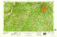
~ Atlanta GA topo map, 1:250000 scale, 1 X 2 Degree, Historical, 1958
Atlanta, Georgia, USGS topographic map dated 1958.
Includes geographic coordinates (latitude and longitude). This topographic map is suitable for hiking, camping, and exploring, or framing it as a wall map.
Printed on-demand using high resolution imagery, on heavy weight and acid free paper, or alternatively on a variety of synthetic materials.
Topos available on paper, Waterproof, Poly, or Tyvek. Usually shipping rolled, unless combined with other folded maps in one order.
- Product Number: USGS-5365336
- Free digital map download (high-resolution, GeoPDF): Atlanta, Georgia (file size: 25 MB)
- Map Size: please refer to the dimensions of the GeoPDF map above
- Weight (paper map): ca. 55 grams
- Map Type: POD USGS Topographic Map
- Map Series: HTMC
- Map Verison: Historical
- Cell ID: 68653
- Scan ID: 247820
- Woodland Tint: Yes
- Aerial Photo Year: 1947
- Field Check Year: 1953
- Datum: Unstated
- Map Projection: Transverse Mercator
- Map published by United States Geological Survey
- Map Language: English
- Scanner Resolution: 600 dpi
- Map Cell Name: Atlanta
- Grid size: 1 X 2 Degree
- Date on map: 1958
- Map Scale: 1:250000
- Geographical region: Georgia, United States
Neighboring Maps:
All neighboring USGS topo maps are available for sale online at a variety of scales.
Spatial coverage:
Topo map Atlanta, Georgia, covers the geographical area associated the following places:
- Adamsville - Quail Valley - Springhill - Clayton Ridge - Songwood - Eastland Heights - Gordon Estates - Gibsonville - Stoneridge - Pyriton - Farmstead - Bobilin Estates - Possum Trot - Shady Grove - Fairview Manor - Kaylor - Woodward - Overlook - The Arbors - Avondale Estates - Virginia Highlands - Morgan - Lester Woods - Heatherbrook - Yorkville - Butlers Mill - Connally - Scarbrough Cross Roads - Cornhouse - Woodland Park - McWhorter - Nebo Place - Hart Circle - Paran - Lime - Weather Wood - Carey Park - Abernathy (historical) - Chigger Ridge (historical) - Cordova - Anniston - Starrs Mill - Powell (historical) - Evergreen - Horseshoe Bend - Chappel - Vinings - Holly Heights - Ace Mobile Home Park - Wasilla Estates - Red Oak - Heatherwood - Marnelle Mobile Home Park - Emerald Hills - Sun Valley - Hobson City - Roosterville - Capstan (historical) - Reidsboro - Creelwood Trailer Park - Carmel Chase - Salem Woods - Lowell - Cumberland Forest - Stallings Crossroad - Red Oak - Woolsey Creek Plantation - Lang (historical) - Sunny Acres - Emerald Forest - Ai - Britt - Ellenwood Homes - Fairfield - Lakeside - Jade Lake Village - Chattahoochee Hills - Bosworth - Barfield - Five Points - Wood Valley Estates - Durelle - Mountain Brooke - Berkeley Manor - Allie - Five Forks - Wallace (historical) - Willowcreek - Hidden Hollow - Austell - Norris Lake Shores - Vel Manor - Center West - The Cloister - Piney Woods Manor - Huntington Creek - Burgess - Belle Grove - Flippen - Towaliga (historical)
- Map Area ID: AREA3433-86-84
- Northwest corner Lat/Long code: USGSNW34-86
- Northeast corner Lat/Long code: USGSNE34-84
- Southwest corner Lat/Long code: USGSSW33-86
- Southeast corner Lat/Long code: USGSSE33-84
- Northern map edge Latitude: 34
- Southern map edge Latitude: 33
- Western map edge Longitude: -86
- Eastern map edge Longitude: -84


