
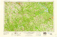
~ Athens GA topo map, 1:250000 scale, 1 X 2 Degree, Historical, 1959
Athens, Georgia, USGS topographic map dated 1959.
Includes geographic coordinates (latitude and longitude). This topographic map is suitable for hiking, camping, and exploring, or framing it as a wall map.
Printed on-demand using high resolution imagery, on heavy weight and acid free paper, or alternatively on a variety of synthetic materials.
Topos available on paper, Waterproof, Poly, or Tyvek. Usually shipping rolled, unless combined with other folded maps in one order.
- Product Number: USGS-5365328
- Free digital map download (high-resolution, GeoPDF): Athens, Georgia (file size: 22 MB)
- Map Size: please refer to the dimensions of the GeoPDF map above
- Weight (paper map): ca. 55 grams
- Map Type: POD USGS Topographic Map
- Map Series: HTMC
- Map Verison: Historical
- Cell ID: 68652
- Scan ID: 247816
- Woodland Tint: Yes
- Aerial Photo Year: 1956
- Field Check Year: 1953
- Datum: Unstated
- Map Projection: Transverse Mercator
- Map published by United States Geological Survey
- Map published by United States Army Corps of Engineers
- Map published by United States Army
- Map Language: English
- Scanner Resolution: 600 dpi
- Map Cell Name: Athens
- Grid size: 1 X 2 Degree
- Date on map: 1959
- Map Scale: 1:250000
- Geographical region: Georgia, United States
Neighboring Maps:
All neighboring USGS topo maps are available for sale online at a variety of scales.
Spatial coverage:
Topo map Athens, Georgia, covers the geographical area associated the following places:
- Juliette - Timbercrest - Porters - Moss Side - Oglethorpe Homes - Hickory Hill - Deerbrook - Briarpatch - Alcovy Mountain - Idylwilde - Hollow Hills - Bridgeport - Prospect - Glennwood - Amity - Neco - Garden Hills - Cedar Bluff - Hadden - Kaolin - Bath - Pepperidge - Westwood - Willington - Brookwood Estates - Fountain Hill (historical) - Hayston - Brickhouse - Wise (historical) - Wheless - Fincher Farms - Sparks - Creekwood Estates - Agnes (historical) - Davison - Canaan - Settlers Grove - Consolidated Government of Augusta-Richmond County (Balance) - Veazey - Windfall Heights - Dacula - Gladesville - Deerfield - Barch Estates - Candlewood Crossing - National Hills - Nicholasville - Tanglebrook - Jennings Mill - Hightower Forest - Forest Estates - Sandy Hill - Mosquito Crossing - Porterdale - Lime Stone (historical) - Elder Heights - Martins Crossroads - Poplar Springs - Valley Forge - Forest Creek - Homewood Hills - Wymberly - Idylwood - Modoc - Broad Acres - Matthews - Wrens Station - Pine Forest - Harrisburg - East Warrenton - Saddleback Estates - Richmond Gardens - Wonderland Estates - Huguenot (historical) - Deepstep - Britain Estates - Vesta - Leah - Raes (historical) - Oak Grove - Resseaus Crossroads - Pine Ridge - Lamkin - Island Shoals (historical) - Bonair - Carmell Mobile Home Park - Carling (historical) - Hunters Ridge - Osceola Village - Dornville (historical) - Lincolnton - North Valley - Anne Heights - Fernbrook - Hickory Point - Paradise Falls - The Briars - Grantville (historical) - Waverly Woods - Hazelbrand Acres
- Map Area ID: AREA3433-84-82
- Northwest corner Lat/Long code: USGSNW34-84
- Northeast corner Lat/Long code: USGSNE34-82
- Southwest corner Lat/Long code: USGSSW33-84
- Southeast corner Lat/Long code: USGSSE33-82
- Northern map edge Latitude: 34
- Southern map edge Latitude: 33
- Western map edge Longitude: -84
- Eastern map edge Longitude: -82


