
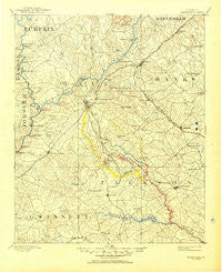
~ Gainesville GA topo map, 1:125000 scale, 30 X 30 Minute, Historical, 1891, updated 1950
Gainesville, Georgia, USGS topographic map dated 1891.
Includes geographic coordinates (latitude and longitude). This topographic map is suitable for hiking, camping, and exploring, or framing it as a wall map.
Printed on-demand using high resolution imagery, on heavy weight and acid free paper, or alternatively on a variety of synthetic materials.
Topos available on paper, Waterproof, Poly, or Tyvek. Usually shipping rolled, unless combined with other folded maps in one order.
- Product Number: USGS-5365240
- Free digital map download (high-resolution, GeoPDF): Gainesville, Georgia (file size: 7 MB)
- Map Size: please refer to the dimensions of the GeoPDF map above
- Weight (paper map): ca. 55 grams
- Map Type: POD USGS Topographic Map
- Map Series: HTMC
- Map Verison: Historical
- Cell ID: 65534
- Scan ID: 247751
- Imprint Year: 1950
- Survey Year: 1889
- Datum: Unstated
- Map Projection: Polyconic
- Map published by United States Geological Survey
- Map Language: English
- Scanner Resolution: 600 dpi
- Map Cell Name: Gainesville
- Grid size: 30 X 30 Minute
- Date on map: 1891
- Map Scale: 1:125000
- Geographical region: Georgia, United States
Neighboring Maps:
All neighboring USGS topo maps are available for sale online at a variety of scales.
Spatial coverage:
Topo map Gainesville, Georgia, covers the geographical area associated the following places:
- Sardis Shores - Woodbridge - Hargrove - Dixie Hills - Whitmire - Southgate - Point View Landing - Chestnut Mountain - Venture Cove - Hoschton - Wolfs Head - Fran Mar Heights - Westgate - Sallee Heights - Trudy Estates - Woodhaven Downs - Pine Forest - Oscarville - Tapawingo - Thyatira - Mulberry - Reed - Shady Valley - Lake Shore - Lake Haven - Tyner - Green Crossing - The Circles - Beard - White Sulphur Springs - Lakeland Heights - Sugar Hill - Crown Point - Mountain View - Holland - Chestnut Hill - Longview - Sunset Heights - Pond Fork (historical) - Vista Brook - Quail Run - Quiet Place in the Woods - New Holland - Meadowood - Chestatee - Oakwood - New Bridge (historical) - Westside - Albert (historical) - Camellia Heights - Cains Courthouse (historical) - Misty Cove - Pine Hills - Clarks Bridge Place - Beach Haven Heights - Broadnax - Chestnut Oak Hills - Thompsons Mill - Lanier North Woods - Squirrel Creek - Gainesville - The Bluffs - Frontier Trail - Chicopee - Olde Federal Pointe - Flowery Branch - Halfway (historical) - Sardis Estates - Goochville - Pine Ridge Point - Welchell - Springlake Estates - Rainbow Village - Klondike - Gilleland - Lake Ranch - Sells - Raintree East - Cascade Woods - Chattahoochee Place - Bellton - Cameron Point - Northlake - Ridgewood - Greenway - Beverly Hills - Braselton - Cherokee Hills - Tanner Mill - Mooney - Weatherford - Cherokee Meadows - Belton - Westview - Red Stone - Elrod - Sardis Heights - Talassee (historical) - Rabbitown - Gainesville Mills
- Map Area ID: AREA34.534-84-83.5
- Northwest corner Lat/Long code: USGSNW34.5-84
- Northeast corner Lat/Long code: USGSNE34.5-83.5
- Southwest corner Lat/Long code: USGSSW34-84
- Southeast corner Lat/Long code: USGSSE34-83.5
- Northern map edge Latitude: 34.5
- Southern map edge Latitude: 34
- Western map edge Longitude: -84
- Eastern map edge Longitude: -83.5


