
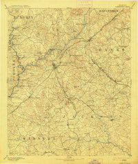
~ Gainesville GA topo map, 1:125000 scale, 30 X 30 Minute, Historical, 1891, updated 1914
Gainesville, Georgia, USGS topographic map dated 1891.
Includes geographic coordinates (latitude and longitude). This topographic map is suitable for hiking, camping, and exploring, or framing it as a wall map.
Printed on-demand using high resolution imagery, on heavy weight and acid free paper, or alternatively on a variety of synthetic materials.
Topos available on paper, Waterproof, Poly, or Tyvek. Usually shipping rolled, unless combined with other folded maps in one order.
- Product Number: USGS-5365236
- Free digital map download (high-resolution, GeoPDF): Gainesville, Georgia (file size: 8 MB)
- Map Size: please refer to the dimensions of the GeoPDF map above
- Weight (paper map): ca. 55 grams
- Map Type: POD USGS Topographic Map
- Map Series: HTMC
- Map Verison: Historical
- Cell ID: 65534
- Scan ID: 247749
- Imprint Year: 1914
- Survey Year: 1889
- Datum: Unstated
- Map Projection: Unstated
- Map published by United States Geological Survey
- Map Language: English
- Scanner Resolution: 600 dpi
- Map Cell Name: Gainesville
- Grid size: 30 X 30 Minute
- Date on map: 1891
- Map Scale: 1:125000
- Geographical region: Georgia, United States
Neighboring Maps:
All neighboring USGS topo maps are available for sale online at a variety of scales.
Spatial coverage:
Topo map Gainesville, Georgia, covers the geographical area associated the following places:
- Timberwood Estates - Oakwood - New Holland - Cool Springs Forest - Hurricane Shoals (historical) - Woodbridge - Tumlin Heights - Klondike - Belvedere Acres - Apple Valley - White Sulphur Station (historical) - Colony South - White Sands - Oak Harbor - Bellton - Chestatee North - Johnson - Stevens - Chestnut Hill - Talassee (historical) - Beach Haven Heights - Shady Lane - Twin Rivers - Westview - Lake Ranch - Thurmack - Rest Haven - Hollingsworth - Moore - Raintree West - Blueberry Hills - Wolfs Head - Baldwin - Gravel Springs - Arcade - Dixie Hills - Pine Haven - Lanier Valley - Rabbitown - Fox Trace - Indian Hills - Gainesville - Raoul - Strickland Heights - Hidden Harbor - Springdale Forest - Shady Valley - Welchell - Sundown on Lanier - Holland - Gilleland - Cherokee Trail - White Sulphur - Dry Pond - Camellia Heights - Fox Hollow - Cains Courthouse (historical) - Holiday Villa - Big Oak - Woodlake - Surf Side Club Estates - Glades - Le Dan - Absalom (historical) - Westgate - Holiday Heights - Red Stone - Trudy - Rainbow Village - Reed - Bretton Woods - Pebble Brook - Cherrywood - Hargrove - Hidden Acres - White Sulphur Springs - Cameron Point - Leisure Lake - Woodhaven Downs - Country Club Gardens - Hughesboro (historical) - Chicopee - Sardis Heights - Jarrett - Belmont - Meadowood - Lanier North Woods - Mulberry - Wildwood Heights - Thompson Mill - Maysville - Lake Watch - Green Hills - Springdale - Fairview - Sallee Heights - Ridgewood - North Banks Cove - Green Meadows - Tyner
- Map Area ID: AREA34.534-84-83.5
- Northwest corner Lat/Long code: USGSNW34.5-84
- Northeast corner Lat/Long code: USGSNE34.5-83.5
- Southwest corner Lat/Long code: USGSSW34-84
- Southeast corner Lat/Long code: USGSSE34-83.5
- Northern map edge Latitude: 34.5
- Southern map edge Latitude: 34
- Western map edge Longitude: -84
- Eastern map edge Longitude: -83.5


