
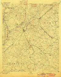
~ Gainesville GA topo map, 1:125000 scale, 30 X 30 Minute, Historical, 1891, updated 1902
Gainesville, Georgia, USGS topographic map dated 1891.
Includes geographic coordinates (latitude and longitude). This topographic map is suitable for hiking, camping, and exploring, or framing it as a wall map.
Printed on-demand using high resolution imagery, on heavy weight and acid free paper, or alternatively on a variety of synthetic materials.
Topos available on paper, Waterproof, Poly, or Tyvek. Usually shipping rolled, unless combined with other folded maps in one order.
- Product Number: USGS-5365234
- Free digital map download (high-resolution, GeoPDF): Gainesville, Georgia (file size: 8 MB)
- Map Size: please refer to the dimensions of the GeoPDF map above
- Weight (paper map): ca. 55 grams
- Map Type: POD USGS Topographic Map
- Map Series: HTMC
- Map Verison: Historical
- Cell ID: 65534
- Scan ID: 247748
- Imprint Year: 1902
- Survey Year: 1889
- Datum: Unstated
- Map Projection: Unstated
- Map published by United States Geological Survey
- Map Language: English
- Scanner Resolution: 600 dpi
- Map Cell Name: Gainesville
- Grid size: 30 X 30 Minute
- Date on map: 1891
- Map Scale: 1:125000
- Geographical region: Georgia, United States
Neighboring Maps:
All neighboring USGS topo maps are available for sale online at a variety of scales.
Spatial coverage:
Topo map Gainesville, Georgia, covers the geographical area associated the following places:
- Saddlewood - Gay Lan - Lanier North Woods - Somerset Hills - White Sulphur Station (historical) - Marlow - Tyner - Whelchel - Botany Woods - Marlette Heights - Lawson Highlands - Tanner Mill - Rainbow Village - Woodlake - Raintree East - Belton - Sidney on Lanier - Fox Hollow - Barrett - Hidden Harbor - Hammer - Maysville - Myrdell Estates - Talmo - Moore - Springdale - North Forest - Habersham Hills - Summer Point - New Holland - Tapawingo - Lanier Valley - Raintree West - Oakwood - Woodbridge - Pine Haven - Pebble Brook - Sallee Heights - Weatherford - Greystone - Sells - Strickland Heights - Whitmire - Lakeshore Estates - Waverly Way - Roberts Crossroads - Crown Point - Maple Forge - Destitute Acres - Whitmire - Belmont - Shady Valley - Mill Ridge - Indian Hills - Squirrel Creek - Glades - Jefferson - Gilleland - Cascade Woods - Thurmack - Oak Harbor - Cool Springs Forest - Le Dan - Alto - The Circles - Green Crossing - Green Hills - Atlas Circle - Timberidge - Flat Creek - Brookton - Tumlin Heights - Thompson Mill - Quail Run - Chapman - Chattahoochee Place - Auburn - Springdale Forest - McEver - Forest Park - Pleasant View - Lake Farm - Johnson - Land (historical) - The Bluffs - Broadnax - North Banks Cove - Sagamore - Vista Brook - Woodhaven Downs - Cain Manor - Pine Ridge Point - Pine Hills - Frazier - Dry Pond - Hidden Acres - Welchell - Bretton Woods - White Sands - Elrod
- Map Area ID: AREA34.534-84-83.5
- Northwest corner Lat/Long code: USGSNW34.5-84
- Northeast corner Lat/Long code: USGSNE34.5-83.5
- Southwest corner Lat/Long code: USGSSW34-84
- Southeast corner Lat/Long code: USGSSE34-83.5
- Northern map edge Latitude: 34.5
- Southern map edge Latitude: 34
- Western map edge Longitude: -84
- Eastern map edge Longitude: -83.5


