
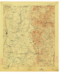
~ Dalton GA topo map, 1:125000 scale, 30 X 30 Minute, Historical, 1897, updated 1913
Dalton, Georgia, USGS topographic map dated 1897.
Includes geographic coordinates (latitude and longitude). This topographic map is suitable for hiking, camping, and exploring, or framing it as a wall map.
Printed on-demand using high resolution imagery, on heavy weight and acid free paper, or alternatively on a variety of synthetic materials.
Topos available on paper, Waterproof, Poly, or Tyvek. Usually shipping rolled, unless combined with other folded maps in one order.
- Product Number: USGS-5365202
- Free digital map download (high-resolution, GeoPDF): Dalton, Georgia (file size: 8 MB)
- Map Size: please refer to the dimensions of the GeoPDF map above
- Weight (paper map): ca. 55 grams
- Map Type: POD USGS Topographic Map
- Map Series: HTMC
- Map Verison: Historical
- Cell ID: 65313
- Scan ID: 247725
- Imprint Year: 1913
- Survey Year: 1895
- Datum: Unstated
- Map Projection: Unstated
- Map published by United States Geological Survey
- Map Language: English
- Scanner Resolution: 600 dpi
- Map Cell Name: Dalton
- Grid size: 30 X 30 Minute
- Date on map: 1897
- Map Scale: 1:125000
- Geographical region: Georgia, United States
Neighboring Maps:
All neighboring USGS topo maps are available for sale online at a variety of scales.
Spatial coverage:
Topo map Dalton, Georgia, covers the geographical area associated the following places:
- New Hope - Pratersville - Five Springs - Temple Grove - Ramhurst - Ollie - Ruralvale - Sumac - North Cohutta (historical) - Parrett Crossing - Midway (historical) - Keiths Mill - Bloodtown - Hasslers Mill - Webb - Carters - Ranger - McDaniel - Carlisle (historical) - Audubon - Dennis - Redbud - Carbondale - Nickelsville - Edgar (historical) - Calhoun - Hunts Corner - Spring Place - Cohutta Springs - Wheeler (historical) - Crandall - Wells (historical) - Pleasant Grove - Cedar Ridge - Colima - Water Valley (historical) - Mountaintown - Dalton - Echota - Talona - Petersburg - Dawnville - Cedar Valley - Prater Mill - Holley - Tilton - Whitestone - Red Clay - Scarecorn - Doogan - Nance Springs - Roosevelt - Clipper - Chatsworth - Fort Mountain (historical) - Union Point - Sweden - Alaculsy - Cannon Heights - Carns Mill - Resaca - Phelps - Plainview - Damascus - Cisco - Buff (historical) - New Town - Gregory - Angelville - Talking Rock - Conasauga (historical) - Tioga - Pleasant Hill - Elders - Blaine - Jones Mill (historical) - Norton - Fillmore (historical) - Tails Creek - Keasley (historical) - Tennga - Ratcliff (historical) - Coosawattee (historical) - Oakman - Rober (historical) - Lewis Corner - Eton - Oran - Beaverdale - Town Creek - Gartrell (historical) - Cohutta - Crown Mill Village - Mills (historical) - Fidelle - Kiker - Treadwell - Crane Eater - Waring - Coniston
- Map Area ID: AREA3534.5-85-84.5
- Northwest corner Lat/Long code: USGSNW35-85
- Northeast corner Lat/Long code: USGSNE35-84.5
- Southwest corner Lat/Long code: USGSSW34.5-85
- Southeast corner Lat/Long code: USGSSE34.5-84.5
- Northern map edge Latitude: 35
- Southern map edge Latitude: 34.5
- Western map edge Longitude: -85
- Eastern map edge Longitude: -84.5


