
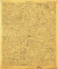
~ Crawfordville GA topo map, 1:125000 scale, 30 X 30 Minute, Historical, 1906
Crawfordville, Georgia, USGS topographic map dated 1906.
Includes geographic coordinates (latitude and longitude). This topographic map is suitable for hiking, camping, and exploring, or framing it as a wall map.
Printed on-demand using high resolution imagery, on heavy weight and acid free paper, or alternatively on a variety of synthetic materials.
Topos available on paper, Waterproof, Poly, or Tyvek. Usually shipping rolled, unless combined with other folded maps in one order.
- Product Number: USGS-5365176
- Free digital map download (high-resolution, GeoPDF): Crawfordville, Georgia (file size: 10 MB)
- Map Size: please refer to the dimensions of the GeoPDF map above
- Weight (paper map): ca. 55 grams
- Map Type: POD USGS Topographic Map
- Map Series: HTMC
- Map Verison: Historical
- Cell ID: 65288
- Scan ID: 247705
- Survey Year: 1904
- Datum: Unstated
- Map Projection: Unstated
- Map published by United States Geological Survey
- Map Language: English
- Scanner Resolution: 600 dpi
- Map Cell Name: Crawfordville
- Grid size: 30 X 30 Minute
- Date on map: 1906
- Map Scale: 1:125000
- Geographical region: Georgia, United States
Neighboring Maps:
All neighboring USGS topo maps are available for sale online at a variety of scales.
Spatial coverage:
Topo map Crawfordville, Georgia, covers the geographical area associated the following places:
- Crawfordville - Sycorax (historical) - Lundberg - Jackson Heights - Lisbon - New Town - Callaway - Bell - Thaxton (historical) - Graball - Enterprise - Little River - Tyrone - Palmetto - Ravenwood Park - Lovelace - Saxon - Wise (historical) - Chennault - Armstrong (historical) - Cohentown - Tignall - Goshen - Logan - Philomath - Lincoln Heights - Huguenot (historical) - Brickhouse - Centerville - Ficklin - Veribest - Edgewood Crossroads - Curry Hill - Hillman - Chatfield (historical) - Norman - Barnett - Oak Grove - Broad - Lina (historical) - Aonia - Robinson - Delhi - Anthony Crossroads - Washington - Metasville - Adasburg - Floral Hill - Possie (historical) - Raytown - Cedar Rock - Anon (historical) - Springfield - Vesta - Sybert - Columbia Mine (historical) - Midway - Rayle - Sandtown - Sharon - Lyneville - Three Points - Tatham Mines (historical) - Anne Heights - Danburg - Jacksons Crossroads - Honora - Beulah - Bessie (historical) - Daniel - Washington Heights - Sandy Hill - Gill - Porters - Carters Grove - Wrightsboro - Linesville - Prather - Dyson (historical) - Cadley - Celeste - Thigpen - Daniel Springs - Fairview - Goose Pond (historical)
- Map Area ID: AREA3433.5-83-82.5
- Northwest corner Lat/Long code: USGSNW34-83
- Northeast corner Lat/Long code: USGSNE34-82.5
- Southwest corner Lat/Long code: USGSSW33.5-83
- Southeast corner Lat/Long code: USGSSE33.5-82.5
- Northern map edge Latitude: 34
- Southern map edge Latitude: 33.5
- Western map edge Longitude: -83
- Eastern map edge Longitude: -82.5


