
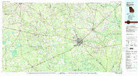
~ Waycross GA topo map, 1:100000 scale, 30 X 60 Minute, Historical, 1978, updated 1982
Waycross, Georgia, USGS topographic map dated 1978.
Includes geographic coordinates (latitude and longitude). This topographic map is suitable for hiking, camping, and exploring, or framing it as a wall map.
Printed on-demand using high resolution imagery, on heavy weight and acid free paper, or alternatively on a variety of synthetic materials.
Topos available on paper, Waterproof, Poly, or Tyvek. Usually shipping rolled, unless combined with other folded maps in one order.
- Product Number: USGS-5365138
- Free digital map download (high-resolution, GeoPDF): Waycross, Georgia (file size: 24 MB)
- Map Size: please refer to the dimensions of the GeoPDF map above
- Weight (paper map): ca. 55 grams
- Map Type: POD USGS Topographic Map
- Map Series: HTMC
- Map Verison: Historical
- Cell ID: 68560
- Scan ID: 247670
- Imprint Year: 1982
- Woodland Tint: Yes
- Aerial Photo Year: 1974
- Edit Year: 1978
- Datum: NAD27
- Map Projection: Universal Transverse Mercator
- Map published by United States Geological Survey
- Map Language: English
- Scanner Resolution: 600 dpi
- Map Cell Name: Waycross
- Grid size: 30 X 60 Minute
- Date on map: 1978
- Map Scale: 1:100000
- Geographical region: Georgia, United States
Neighboring Maps:
All neighboring USGS topo maps are available for sale online at a variety of scales.
Spatial coverage:
Topo map Waycross, Georgia, covers the geographical area associated the following places:
- Youman - Cutting - Pine Valley - Schlatterville - Waycross - Sand Hill - Deenwood - Three Points - Homestead - Needham - Paletree - Stokesville - Garlington Heights Housing Project - Kirkland - Fairfax - Leliaton - Mora - Hoboken - Fivemile Still - Crews Crossing - Cogdell - Dixie Union - Glenmore - Patterson - Bay Meadows - Winona Park - Satilla Village Mobile Home Park - Traisville - Wahoma - Fort Mudge - Crawley - Axson - Haywood - Waresboro - Emerson Park - Hasty - Martins Mobile Home Park - Sappville - Bolen - Manor - Winokur - Bickley - Waltertown - Oberry - Astoria - Sirmans - Wilsonville - Hebardville - Sandy Bottom - Argyle - Racepond - Aspinwall - Eightmile Still - Lakeside Mobile Home Park - Gillicon - Homerville - Henderson Still - Blackshear - Pearson - Walkersville - Owen - Viviani - Otter Creek - Zirkle (historical) - Bachlott - Beach - Mershon - Jamestown - Bristol - Braganza - Bethel - Mexico Crossing - Offerman - Screven - Sunnyside - Talmo - Skullhead - Millwood - Ruskin - Hinson Crossing
- Map Area ID: AREA31.531-83-82
- Northwest corner Lat/Long code: USGSNW31.5-83
- Northeast corner Lat/Long code: USGSNE31.5-82
- Southwest corner Lat/Long code: USGSSW31-83
- Southeast corner Lat/Long code: USGSSE31-82
- Northern map edge Latitude: 31.5
- Southern map edge Latitude: 31
- Western map edge Longitude: -83
- Eastern map edge Longitude: -82


