
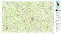
~ Vidalia GA topo map, 1:100000 scale, 30 X 60 Minute, Historical, 1979, updated 1980
Vidalia, Georgia, USGS topographic map dated 1979.
Includes geographic coordinates (latitude and longitude). This topographic map is suitable for hiking, camping, and exploring, or framing it as a wall map.
Printed on-demand using high resolution imagery, on heavy weight and acid free paper, or alternatively on a variety of synthetic materials.
Topos available on paper, Waterproof, Poly, or Tyvek. Usually shipping rolled, unless combined with other folded maps in one order.
- Product Number: USGS-5365132
- Free digital map download (high-resolution, GeoPDF): Vidalia, Georgia (file size: 30 MB)
- Map Size: please refer to the dimensions of the GeoPDF map above
- Weight (paper map): ca. 55 grams
- Map Type: POD USGS Topographic Map
- Map Series: HTMC
- Map Verison: Historical
- Cell ID: 68526
- Scan ID: 247666
- Imprint Year: 1980
- Woodland Tint: Yes
- Aerial Photo Year: 1974
- Edit Year: 1979
- Datum: NAD27
- Map Projection: Universal Transverse Mercator
- Map published by United States Geological Survey
- Map Language: English
- Scanner Resolution: 600 dpi
- Map Cell Name: Vidalia
- Grid size: 30 X 60 Minute
- Date on map: 1979
- Map Scale: 1:100000
- Geographical region: Georgia, United States
Neighboring Maps:
All neighboring USGS topo maps are available for sale online at a variety of scales.
Spatial coverage:
Topo map Vidalia, Georgia, covers the geographical area associated the following places:
- Canoe - Alston - Sigurd (historical) - Rockledge - Tweed - Petross - Zaidee - Toombs Central - Kibbee - Erick - Orianna - Lyons - New Branch - Santa Claus - McGregor - Ochwalkee - Avants - Ponderosa - Cedar Grove - Ailey - Manassas - Elton (historical) - Barnhill - Walkee (historical) - Bradleys (historical) - Aline - Oak Park - Reidsville - Lombard - Olifftown - Cobbtown - Long Pond - Collins - Lothair - Uvalda - Gillis Springs - Minter - Metter - Five Points - Helena - Wesley - Charlotteville - Vidalia - Spring Hill - Scotland - Five Points - Danton (historical) - McRae - South Thompson - Higgston - Lollie (historical) - Union - Johnson Corner - Center - Normantown - Stillmore - Hatoff (historical) - Lowery - Hughland - Lexsy - Garretta - Harlow - Towns - Cedar Crossing - Mount Vernon - Soperton - Alamo - Charles - Nunez - Shamrock - Oak Grove - Blackville - Glenwood - Tarrytown - Rock Springs - Stuckey - Achord - Mayberry (historical) - Jordan - Ohoopee - Rentz - Orland - Covena
- Map Area ID: AREA32.532-83-82
- Northwest corner Lat/Long code: USGSNW32.5-83
- Northeast corner Lat/Long code: USGSNE32.5-82
- Southwest corner Lat/Long code: USGSSW32-83
- Southeast corner Lat/Long code: USGSSE32-82
- Northern map edge Latitude: 32.5
- Southern map edge Latitude: 32
- Western map edge Longitude: -83
- Eastern map edge Longitude: -82


