
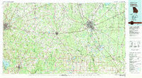
~ Valdosta GA topo map, 1:100000 scale, 30 X 60 Minute, Historical, 1981, updated 1981
Valdosta, Georgia, USGS topographic map dated 1981.
Includes geographic coordinates (latitude and longitude). This topographic map is suitable for hiking, camping, and exploring, or framing it as a wall map.
Printed on-demand using high resolution imagery, on heavy weight and acid free paper, or alternatively on a variety of synthetic materials.
Topos available on paper, Waterproof, Poly, or Tyvek. Usually shipping rolled, unless combined with other folded maps in one order.
- Product Number: USGS-5365130
- Free digital map download (high-resolution, GeoPDF): Valdosta, Georgia (file size: 28 MB)
- Map Size: please refer to the dimensions of the GeoPDF map above
- Weight (paper map): ca. 55 grams
- Map Type: POD USGS Topographic Map
- Map Series: HTMC
- Map Verison: Historical
- Cell ID: 68511
- Scan ID: 247665
- Imprint Year: 1981
- Woodland Tint: Yes
- Aerial Photo Year: 1974
- Edit Year: 1981
- Datum: NAD27
- Map Projection: Universal Transverse Mercator
- Map published by United States Geological Survey
- Map Language: English
- Scanner Resolution: 600 dpi
- Map Cell Name: Valdosta
- Grid size: 30 X 60 Minute
- Date on map: 1981
- Map Scale: 1:100000
- Geographical region: Georgia, United States
Neighboring Maps:
All neighboring USGS topo maps are available for sale online at a variety of scales.
Spatial coverage:
Topo map Valdosta, Georgia, covers the geographical area associated the following places:
- Mayday - Oaklawn - Academy Acres - Maysland - Sand Hill - Lovett - Dasher - Octahatchee - Forresthill Estates - Hollis - Everett - Thomasville - Newsome - Twin Lakes - Macville (historical) - Lambville (historical) - Barko Village - Alapaha (historical) - Avoca - Northwood - Hanson - Theodore Heights - Touraine (historical) - McLoughlin Heights - Tillman - Tillman (historical) - Spray - Alma - Dixie - Jennings - Metcalf - Jarrett - Pasco - Lincoln Park - Lake Park - Ousley - Schoer Estates - Golden (historical) - North Gate Manor Trailer Park - Dewey City - Foxborough - Kennedy (historical) - Herring - Cherry Lake - Shiloh - Grooverville - Bailey - Greens Crossing - Patten - Naylor - Empress - Briggston - Nankin - Gates (historical) - Lawton - Gulf Atlantic Trailer Park - Glasgow - South Ree Springs - Shiver - Montivilla - Fourth Street Trailer Park - Clyattville - Homestead Park - Morven - San Juan Ospalaga (historical) - Fredonia - Statenville - Bemiss - Forrestwood Estates - Five Forks - Piscola - Windsor Park - Remerton - Fincher - Hamburg - Eager - McIntyre Spring (historical) - Beverly (historical) - Roddenberry (historical) - Dills - Seaford (historical) - Westwood Estates - Spain - Mineola - Highland Heights - Ashville - Booker Heights - Forrest Place - Indianola - Newark - Tallokas (historical) - Lois - Bray (historical) - West Valdosta - Festus - Eastwind - Antioch (historical) - Bandy - Pidcock - Quitman
- Map Area ID: AREA3130.5-84-83
- Northwest corner Lat/Long code: USGSNW31-84
- Northeast corner Lat/Long code: USGSNE31-83
- Southwest corner Lat/Long code: USGSSW30.5-84
- Southeast corner Lat/Long code: USGSSE30.5-83
- Northern map edge Latitude: 31
- Southern map edge Latitude: 30.5
- Western map edge Longitude: -84
- Eastern map edge Longitude: -83


