
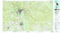
~ Macon GA topo map, 1:100000 scale, 30 X 60 Minute, Historical, 1978, updated 1980
Macon, Georgia, USGS topographic map dated 1978.
Includes geographic coordinates (latitude and longitude). This topographic map is suitable for hiking, camping, and exploring, or framing it as a wall map.
Printed on-demand using high resolution imagery, on heavy weight and acid free paper, or alternatively on a variety of synthetic materials.
Topos available on paper, Waterproof, Poly, or Tyvek. Usually shipping rolled, unless combined with other folded maps in one order.
- Product Number: USGS-5365110
- Free digital map download (high-resolution, GeoPDF): Macon, Georgia (file size: 29 MB)
- Map Size: please refer to the dimensions of the GeoPDF map above
- Weight (paper map): ca. 55 grams
- Map Type: POD USGS Topographic Map
- Map Series: HTMC
- Map Verison: Historical
- Cell ID: 67886
- Scan ID: 247651
- Imprint Year: 1980
- Woodland Tint: Yes
- Aerial Photo Year: 1974
- Edit Year: 1978
- Datum: NAD27
- Map Projection: Universal Transverse Mercator
- Map published by United States Geological Survey
- Map Language: English
- Scanner Resolution: 600 dpi
- Map Cell Name: Macon
- Grid size: 30 X 60 Minute
- Date on map: 1978
- Map Scale: 1:100000
- Geographical region: Georgia, United States
Neighboring Maps:
All neighboring USGS topo maps are available for sale online at a variety of scales.
Spatial coverage:
Topo map Macon, Georgia, covers the geographical area associated the following places:
- Ohio - Joycliff Estates - Liberty View - Kings Park - Smithsonia - Montrose - Idle Hour Estates - Brookwood - Log Cabin Heights - Creekside - Pancras - Woodard Estates - Vonreg Subdivision - Grogan - Sleepy Hollow - Taylors Mill - Gordon - Sardis Estates - Tanglewood - South Oaks - Brookwood Hills - Jones Acres - Stratford Oaks - Lake Sardis Estates - Sherwood Forest - Groveland Park - Stratford Oaks - Bloomfield Farms - Fort Valley - Ceres - Lashley - Trails End - Allentown - Stallworth Trailer Park - Quail Run - Goodall Estates - Peach Valley - Kings Cove - Christian Rest - Dedrich - Pineworth by the Lake - Stratton - Westminister - Coopers - Chappells Mill - Crestwell Heights - Lakeview - Claybed - Rockmill (historical) - Molena Mobile Home Park - Parker (historical) - Arkwright - Briarwood Hill - Irwinton - Washington Square - Glenhaven - Wimbish Hills - Marion - Dixie - Willow Lake - Wheeler Heights - Vinson Village - Shirley Hills Estates - Lindsey Park - Tharpe (historical) - Redding - Morton - Shirley Hills - Sofkee Estates - Walden - Franklinton - Pilgrim Rest - Stathams Landing - Russell Glen - Plentitude (historical) - Echeconnee Acres - Ivey - Wesleyan Hills - Thornwood - Woody Acres - Wesleyan Woods - Holly Bluff - Oglethorpe Homes - Bloomfield Estates - Wimbish Wood - Bullard - Lewiston - Bolingbroke - Wellington Woods - Silver Pines - South Highlands - Highland Circle - Camelot - Castlegate - Riverside Park - Powersville - Pine Forest - Alpine Heights - Beaveroaks - Postell
- Map Area ID: AREA3332.5-84-83
- Northwest corner Lat/Long code: USGSNW33-84
- Northeast corner Lat/Long code: USGSNE33-83
- Southwest corner Lat/Long code: USGSSW32.5-84
- Southeast corner Lat/Long code: USGSSE32.5-83
- Northern map edge Latitude: 33
- Southern map edge Latitude: 32.5
- Western map edge Longitude: -84
- Eastern map edge Longitude: -83


