
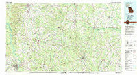
~ Dublin GA topo map, 1:100000 scale, 30 X 60 Minute, Historical, 1981, updated 1981
Dublin, Georgia, USGS topographic map dated 1981.
Includes geographic coordinates (latitude and longitude). This topographic map is suitable for hiking, camping, and exploring, or framing it as a wall map.
Printed on-demand using high resolution imagery, on heavy weight and acid free paper, or alternatively on a variety of synthetic materials.
Topos available on paper, Waterproof, Poly, or Tyvek. Usually shipping rolled, unless combined with other folded maps in one order.
- Product Number: USGS-5365096
- Free digital map download (high-resolution, GeoPDF): Dublin, Georgia (file size: 26 MB)
- Map Size: please refer to the dimensions of the GeoPDF map above
- Weight (paper map): ca. 55 grams
- Map Type: POD USGS Topographic Map
- Map Series: HTMC
- Map Verison: Historical
- Cell ID: 72153
- Scan ID: 247640
- Imprint Year: 1981
- Woodland Tint: Yes
- Aerial Photo Year: 1974
- Edit Year: 1981
- Datum: NAD27
- Map Projection: Universal Transverse Mercator
- Map published by United States Geological Survey
- Map Language: English
- Scanner Resolution: 600 dpi
- Map Cell Name: Dublin
- Grid size: 30 X 60 Minute
- Date on map: 1981
- Map Scale: 1:100000
- Geographical region: Georgia, United States
Neighboring Maps:
All neighboring USGS topo maps are available for sale online at a variety of scales.
Spatial coverage:
Topo map Dublin, Georgia, covers the geographical area associated the following places:
- Holly Hills - Riddleville - Tuckers Crossroad - Rose - Kirby - Davisboro - Meeks - Harrison - Stevens Crossing - Herndon - Butts - Dellwood - Norristown Junction - Sandersville - Rosier - Peacocks Crossing - Keenes Crossing (historical) - Oconee - Condor - Hazard - Bartow - Gardner - Scott - Bales (historical) - Magruder - Wrightsville - Garfield - Midway - Rogers - Tennille - Sun Hill - Lovett - Cunningham Corner - Modoc - Moxley - Old Town - Almira - Durdenville - Pine Hill - Heidrich - Twin City - Kite - Gary - Blundale - Canoochee - Catlin - Old Condor - Wadley - Gertrude - Midville - Birdsville - Donovan - Tabernacle - Tanner - Bellevue - East Dublin - Cushingville (historical) - Bennetts Landing - Colemans Lake - Norristown - Scotts Corner - Brook Springs - Number Ten (historical) - Three Points - Spann - Manning (historical) - Moores - Pinetucky (historical) - Summertown - Tom - Thrift - Veal - Pringle - Old Dellwood - Irwins Crossroads - Brewton - Aldreds - Swainsboro - Hebron - Ennis - Adrian - Blun - Dublin
- Map Area ID: AREA3332.5-83-82
- Northwest corner Lat/Long code: USGSNW33-83
- Northeast corner Lat/Long code: USGSNE33-82
- Southwest corner Lat/Long code: USGSSW32.5-83
- Southeast corner Lat/Long code: USGSSE32.5-82
- Northern map edge Latitude: 33
- Southern map edge Latitude: 32.5
- Western map edge Longitude: -83
- Eastern map edge Longitude: -82


