
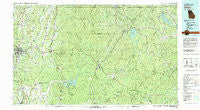
~ Dalton GA topo map, 1:100000 scale, 30 X 60 Minute, Historical, 1981, updated 1982
Dalton, Georgia, USGS topographic map dated 1981.
Includes geographic coordinates (latitude and longitude). This topographic map is suitable for hiking, camping, and exploring, or framing it as a wall map.
Printed on-demand using high resolution imagery, on heavy weight and acid free paper, or alternatively on a variety of synthetic materials.
Topos available on paper, Waterproof, Poly, or Tyvek. Usually shipping rolled, unless combined with other folded maps in one order.
- Product Number: USGS-5365094
- Free digital map download (high-resolution, GeoPDF): Dalton, Georgia (file size: 31 MB)
- Map Size: please refer to the dimensions of the GeoPDF map above
- Weight (paper map): ca. 55 grams
- Map Type: POD USGS Topographic Map
- Map Series: HTMC
- Map Verison: Historical
- Cell ID: 67379
- Scan ID: 247638
- Imprint Year: 1982
- Woodland Tint: Yes
- Aerial Photo Year: 1972
- Edit Year: 1981
- Datum: NAD27
- Map Projection: Universal Transverse Mercator
- Map published by United States Geological Survey
- Map Language: English
- Scanner Resolution: 600 dpi
- Map Cell Name: Dalton
- Grid size: 30 X 60 Minute
- Date on map: 1981
- Map Scale: 1:100000
- Geographical region: Georgia, United States
Neighboring Maps:
All neighboring USGS topo maps are available for sale online at a variety of scales.
Spatial coverage:
Topo map Dalton, Georgia, covers the geographical area associated the following places:
- Carters - Prater Mill - Chatsworth - Nickelsville - Tickanetley - Dial - Thomas Mill - Talona - Madola - Fry - Yukon - Alaculsy - Oakman - Wright Mill - Forge Mill - Elrod Mill - Cartecay - Cannon Heights - Red Clay - Staffordtown - Dawnville - Williamstown - New Town - McDaniel - Gartrell (historical) - McCaysville - Amicalola - Murphy Junction - Youngcane (historical) - Chopped Oak - Damascus - Ivylog - Higdon Mill (historical) - Elders - Oasis - Marion - Fillmore (historical) - Ollie - Goose Island - Sweet Gum - Snider (historical) - Padena - Pratersville - Cherry Log - Kingtown - Salem - Roy - Kyle - Sugar Hill - Baxter - Cutcane - Roundtop - Blaine - Hedwig (historical) - Petersburg - Decora - Mineral Bluff - Oran - Keiths Mill - Bloodtown - Spring Place - Ellijay - Lance Mill - Sarah - Audubon - Whitestone - Roosevelt - Stock Hill - Coniston - Emma - Suches - Stanley Mill (historical) - Dalton - Nimblewill - Cohutta Springs - Hothouse - Mills (historical) - Wells (historical) - Coles Crossing - Santaluca - Ball Ground - Buckhorn Tavern - Cohutta - Pisgah - Windy Ridge - Tate Mountain Estates - Galloway - Cedar Valley - Five Springs - Turniptown (historical) - Ratcliff (historical) - Crown Mill Village - Ruralvale - Greens Mill - Jones Creek - Burnt Mountain Estates - Varnell - Hurst - Higdon - Sparks Mill
- Map Area ID: AREA3534.5-85-84
- Northwest corner Lat/Long code: USGSNW35-85
- Northeast corner Lat/Long code: USGSNE35-84
- Southwest corner Lat/Long code: USGSSW34.5-85
- Southeast corner Lat/Long code: USGSSE34.5-84
- Northern map edge Latitude: 35
- Southern map edge Latitude: 34.5
- Western map edge Longitude: -85
- Eastern map edge Longitude: -84


