
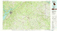
~ Commerce GA topo map, 1:100000 scale, 30 X 60 Minute, Historical, 1979, updated 1980
Commerce, Georgia, USGS topographic map dated 1979.
Includes geographic coordinates (latitude and longitude). This topographic map is suitable for hiking, camping, and exploring, or framing it as a wall map.
Printed on-demand using high resolution imagery, on heavy weight and acid free paper, or alternatively on a variety of synthetic materials.
Topos available on paper, Waterproof, Poly, or Tyvek. Usually shipping rolled, unless combined with other folded maps in one order.
- Product Number: USGS-5365090
- Free digital map download (high-resolution, GeoPDF): Commerce, Georgia (file size: 30 MB)
- Map Size: please refer to the dimensions of the GeoPDF map above
- Weight (paper map): ca. 55 grams
- Map Type: POD USGS Topographic Map
- Map Series: HTMC
- Map Verison: Historical
- Cell ID: 67324
- Scan ID: 247635
- Imprint Year: 1980
- Woodland Tint: Yes
- Aerial Photo Year: 1974
- Edit Year: 1979
- Datum: NAD27
- Map Projection: Universal Transverse Mercator
- Map published by United States Geological Survey
- Map Language: English
- Scanner Resolution: 600 dpi
- Map Cell Name: Commerce
- Grid size: 30 X 60 Minute
- Date on map: 1979
- Map Scale: 1:100000
- Geographical region: Georgia, United States
Neighboring Maps:
All neighboring USGS topo maps are available for sale online at a variety of scales.
Spatial coverage:
Topo map Commerce, Georgia, covers the geographical area associated the following places:
- Pinefield Crossroads - Holiday Heights - Saddlewood - Thompson Mill - Waverly Way - Unity - Rest Haven - North Forest - Colony South - Goochville - Pruitt - Looper Lake - Homer - Broadnax - Cascade Woods - Raoul - Longview - Maple Forge - Tapawingo - Madison Springs - Belton - Match - Botany Woods - Hughesboro (historical) - Gower Springs (historical) - Cherokee Forest - Woodbriar East - Greenway - Timberwood Estates - Pinecrest Heights - Klondike - Carlton - Rainbow Village - Olde Federal Pointe - Chapman - Cherokee Hills - Lawson Highlands - New Bridge (historical) - Wilbanks Corner - Mountain View - Grove Level - Parhams - Bentwood - Country Corner Mobile Home Park - Dunagan - Meadowood - Quail Run - Woodhaven Downs - Sunset Heights - Cherokee Trail - Chattahoochee Place - Frazier - Gumlog - Ahaluna - Hayes - Tanner Mill - Johnson - Bark Camp Place - Pine Ridge Point - Clarksboro - Lavonia - Bowman - Pine Point - Indian Hills - Clarks Bridge - Griffin Heights - Venture Cove - Braselton - Nickville - Le Dan - Summer Point - Woodbridge - Jewelville - Mulberry - New Holland - Sanford - Hix - Nancytown (historical) - Lake Shore - Big Oak - Holiday Villa - Gholston Stand Crossroads - Carnesville - Marlow - Sagamore - Minish - Smiths Store - Springdale Forest - Ridgewood - Shiloh - Woodlake - Dalton - Cromers - Marcus (historical) - Dowdy (historical) - Phillips - Sardis Heights - Mundys Point - Pocataligo - Gravel Springs
- Map Area ID: AREA34.534-84-83
- Northwest corner Lat/Long code: USGSNW34.5-84
- Northeast corner Lat/Long code: USGSNE34.5-83
- Southwest corner Lat/Long code: USGSSW34-84
- Southeast corner Lat/Long code: USGSSE34-83
- Northern map edge Latitude: 34.5
- Southern map edge Latitude: 34
- Western map edge Longitude: -84
- Eastern map edge Longitude: -83


