
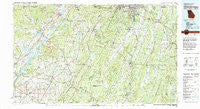
~ Chickamauga GA topo map, 1:100000 scale, 30 X 60 Minute, Historical, 1981, updated 1982
Chickamauga, Georgia, USGS topographic map dated 1981.
Includes geographic coordinates (latitude and longitude). This topographic map is suitable for hiking, camping, and exploring, or framing it as a wall map.
Printed on-demand using high resolution imagery, on heavy weight and acid free paper, or alternatively on a variety of synthetic materials.
Topos available on paper, Waterproof, Poly, or Tyvek. Usually shipping rolled, unless combined with other folded maps in one order.
- Product Number: USGS-5365086
- Free digital map download (high-resolution, GeoPDF): Chickamauga, Georgia (file size: 29 MB)
- Map Size: please refer to the dimensions of the GeoPDF map above
- Weight (paper map): ca. 55 grams
- Map Type: POD USGS Topographic Map
- Map Series: HTMC
- Map Verison: Historical
- Cell ID: 67287
- Scan ID: 247632
- Imprint Year: 1982
- Woodland Tint: Yes
- Aerial Photo Year: 1972
- Edit Year: 1981
- Datum: NAD27
- Map Projection: Universal Transverse Mercator
- Map published by United States Geological Survey
- Map Language: English
- Scanner Resolution: 600 dpi
- Map Cell Name: Chickamauga
- Grid size: 30 X 60 Minute
- Date on map: 1981
- Map Scale: 1:100000
- Geographical region: Georgia, United States
Neighboring Maps:
All neighboring USGS topo maps are available for sale online at a variety of scales.
Spatial coverage:
Topo map Chickamauga, Georgia, covers the geographical area associated the following places:
- Walnut Hills - Belvoir Terrace - Stevenson - Beaty Crossroads - Cenchat - Gonce - Dickey (historical) - West Brow - Mountain View - Ellie Spring - Cooper Heights - Cloverdale - LaFayette - Saint Elmo - Wannville - Wallaceville - Bass - Euthtilloga (historical) - Blevins Acre - Copeland Crossing - Oak Grove - Mount Carmel - Marsh Crossing - Deer Head Cove - Amos Mill - Cartersville - Gordon Springs (historical) - Dietz - Blake - Fantasy Hills - Hooker - Happy Valley - Pinder Hill - Hall Mill - Mount Pisgah - Pond Spring - Fairview Heights - Biddle Crossroads - Red Belt - Cedar Grove - Green Hills - Catlett - Waverly Park - Hammondville - Henagar - White Oak - Valley Head - Flintstone - Long Island - Rosalie - Bolivar - Tunnel Hill - East Armuchee - Hassler Mill - Hancock Crossroads - Keith - Shiloh - Beatum - Hollywood - Rocky Face - Piney Woods - Cannon Crossing - Sulphur Springs Station - Masseyville - Warren Terrace - Dutton - Corinth - Card Switch - Musgrove (historical) - Salem - Love Hill - Fairlawn Acres - Bryant - Mount Carmel - New Town - Ascalon - Cole City - Winwood Forest - Spencer Hills - High Point - Mana Estates - Mahan (historical) - Reo - Beulah - Pinewood Estates - Lookout Mountain - Graysville - Hymer (historical) - Laurelwood Estates - Walnut Grove - Mahan Crossroads - Georgetown - John Ross Estates - Ringgold - Bellview - Catoosa Springs - Trenton - Carns - Boynton - Davis Crossroads
- Map Area ID: AREA3534.5-86-85
- Northwest corner Lat/Long code: USGSNW35-86
- Northeast corner Lat/Long code: USGSNE35-85
- Southwest corner Lat/Long code: USGSSW34.5-86
- Southeast corner Lat/Long code: USGSSE34.5-85
- Northern map edge Latitude: 35
- Southern map edge Latitude: 34.5
- Western map edge Longitude: -86
- Eastern map edge Longitude: -85


