
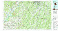
~ Chickamauga GA topo map, 1:100000 scale, 30 X 60 Minute, Historical, 1981, updated 1982
Chickamauga, Georgia, USGS topographic map dated 1981.
Includes geographic coordinates (latitude and longitude). This topographic map is suitable for hiking, camping, and exploring, or framing it as a wall map.
Printed on-demand using high resolution imagery, on heavy weight and acid free paper, or alternatively on a variety of synthetic materials.
Topos available on paper, Waterproof, Poly, or Tyvek. Usually shipping rolled, unless combined with other folded maps in one order.
- Product Number: USGS-5365084
- Free digital map download (high-resolution, GeoPDF): Chickamauga, Georgia (file size: 30 MB)
- Map Size: please refer to the dimensions of the GeoPDF map above
- Weight (paper map): ca. 55 grams
- Map Type: POD USGS Topographic Map
- Map Series: HTMC
- Map Verison: Historical
- Cell ID: 67287
- Scan ID: 247631
- Imprint Year: 1982
- Woodland Tint: Yes
- Visual Version Number: 2
- Aerial Photo Year: 1972
- Edit Year: 1981
- Datum: NAD27
- Map Projection: Universal Transverse Mercator
- Map published by United States Geological Survey
- Map Language: English
- Scanner Resolution: 600 dpi
- Map Cell Name: Chickamauga
- Grid size: 30 X 60 Minute
- Date on map: 1981
- Map Scale: 1:100000
- Geographical region: Georgia, United States
Neighboring Maps:
All neighboring USGS topo maps are available for sale online at a variety of scales.
Spatial coverage:
Topo map Chickamauga, Georgia, covers the geographical area associated the following places:
- McCutchen (historical) - Mountain View - Bankhead - New Home - Brookvale Estates - Meadowview - Moons - Duck Creek (historical) - Cartersville - Skaggs Corner - Pisgah - Furnace (historical) - Spencer Hills - Ider - Flintstone - Morganville - Henagar - Rocky Face - Summer Bluff - Talley (historical) - Hill City - East Boynton - Hodge - Warren Terrace - Dogwood Circle - Scenic Hills - Snake Creek (historical) - Fairfield (historical) - Amos Mill - Anderson - Walnut Grove - Mount Pisgah - Mitchell Acres - Bryant - Waverly Park - Old Fort Estates - Oak Park - Keith - Laurelwood Estates - Westside - Gonce - Kirby Creek (historical) - Martintown - Avans - Mount Vernon - Cloverdale - Long Island - Greenwood - Saint Elmo - Shadynook - Flat Rock - Mana Estates - Cedar Hill - East Armuchee - Wannville - Cedar Grove - Stone Church - Salem (historical) - Burning Bush - Summit Hill - Skyline Heights - Morris Estates - Gerber (historical) - Green Acres - Beulah - Ellie Spring - Hall Mill - Euthtilloga (historical) - Durham - Glenzaida - Cloud Springs - Opeleika (historical) - Old Blevins Mill - Stamp - Rising Fawn - Bridgeport - Riverland Estates - Edgefield - Nacoochee Point Subdivision - Hannah (historical) - Central - Salem - John Ross Estates - South Rossville - Shellmound (historical) - Cooper Heights - Kensington - Duncan Crossroads - Rocky Springs - New Town - Fantasy Hills - Lansdell Park - Dietz - Allison - Villanow - Lakeview - Widows Creek Station - Hymer (historical) - Bass - West Brow
- Map Area ID: AREA3534.5-86-85
- Northwest corner Lat/Long code: USGSNW35-86
- Northeast corner Lat/Long code: USGSNE35-85
- Southwest corner Lat/Long code: USGSSW34.5-86
- Southeast corner Lat/Long code: USGSSE34.5-85
- Northern map edge Latitude: 35
- Southern map edge Latitude: 34.5
- Western map edge Longitude: -86
- Eastern map edge Longitude: -85


