
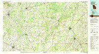
~ Camilla GA topo map, 1:100000 scale, 30 X 60 Minute, Historical, 1981, updated 1982
Camilla, Georgia, USGS topographic map dated 1981.
Includes geographic coordinates (latitude and longitude). This topographic map is suitable for hiking, camping, and exploring, or framing it as a wall map.
Printed on-demand using high resolution imagery, on heavy weight and acid free paper, or alternatively on a variety of synthetic materials.
Topos available on paper, Waterproof, Poly, or Tyvek. Usually shipping rolled, unless combined with other folded maps in one order.
- Product Number: USGS-5365080
- Free digital map download (high-resolution, GeoPDF): Camilla, Georgia (file size: 25 MB)
- Map Size: please refer to the dimensions of the GeoPDF map above
- Weight (paper map): ca. 55 grams
- Map Type: POD USGS Topographic Map
- Map Series: HTMC
- Map Verison: Historical
- Cell ID: 67217
- Scan ID: 247627
- Imprint Year: 1982
- Woodland Tint: Yes
- Aerial Photo Year: 1974
- Edit Year: 1981
- Datum: NAD27
- Map Projection: Universal Transverse Mercator
- Map published by United States Geological Survey
- Map Language: English
- Scanner Resolution: 600 dpi
- Map Cell Name: Camilla
- Grid size: 30 X 60 Minute
- Date on map: 1981
- Map Scale: 1:100000
- Geographical region: Georgia, United States
Neighboring Maps:
All neighboring USGS topo maps are available for sale online at a variety of scales.
Spatial coverage:
Topo map Camilla, Georgia, covers the geographical area associated the following places:
- Hawkinstown - Branchville - Vada - Crestview - Boykin - Douglasville - Town and Country Subdivision Number 2 - Lamar - Meigs - Pleasant Hill (historical) - Petty (historical) - Hollands Folly - Douglass Crossroads - Jeterville - Mount Pleasant - Hinsonton - Crossroads - Saco (historical) - Macedonia - Williamsburg - Dewsville (historical) - Cooktown - Enterprise - Williamsburg - Sharphagen - Patmos - Horns Cross Road (historical) - Cheevertown (historical) - Lucile - Laney - Bermuda - Mimsville - Little Hope - Colquitt - Dozier (historical) - River Bend - Greenough - Harrells Still - Killarney - McLendon (historical) - Greenwood - Newton - Twilight (historical) - Hansell - Floydtown (historical) - Bethany - Commissary Hill - Adelaide - Loretta Heights - Leary - Hentown - Joe Shingler (historical) - Pawnee - Ferrell Crossroads - Cuba - Iron City - Rogerville - Oak Grove (historical) - Bancroft - Babcock - Putney - Pelham - Camilla - Spence - Baconton - Jones Spur - Hopeful - Corea - Hoggard Mill - Arlington - New Hope - Centerville - Elmodel - Rowena - Akridge (historical) - Town and Country Estates - Blakely - Flint - Springfield (historical) - Damascus - Lester - Jakin - Iveys Mill - Pine Lake Estates - Colomokee - Red Store Crossroads - Union Hill - Eldorendo - Howards Mill - Nicholasville - Spooner (historical) - Sale City - DeWitt - Mayhaw - Milford - Cotton - Donalsonville - Bellview - Nicholasville (historical) - Pebble City
- Map Area ID: AREA31.531-85-84
- Northwest corner Lat/Long code: USGSNW31.5-85
- Northeast corner Lat/Long code: USGSNE31.5-84
- Southwest corner Lat/Long code: USGSSW31-85
- Southeast corner Lat/Long code: USGSSE31-84
- Northern map edge Latitude: 31.5
- Southern map edge Latitude: 31
- Western map edge Longitude: -85
- Eastern map edge Longitude: -84


