
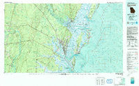
~ Brunswick GA topo map, 1:100000 scale, 30 X 60 Minute, Historical, 1981, updated 1993
Brunswick, Georgia, USGS topographic map dated 1981.
Includes geographic coordinates (latitude and longitude). This topographic map is suitable for hiking, camping, and exploring, or framing it as a wall map.
Printed on-demand using high resolution imagery, on heavy weight and acid free paper, or alternatively on a variety of synthetic materials.
Topos available on paper, Waterproof, Poly, or Tyvek. Usually shipping rolled, unless combined with other folded maps in one order.
- Product Number: USGS-5365078
- Free digital map download (high-resolution, GeoPDF): Brunswick, Georgia (file size: 31 MB)
- Map Size: please refer to the dimensions of the GeoPDF map above
- Weight (paper map): ca. 55 grams
- Map Type: POD USGS Topographic Map
- Map Series: HTMC
- Map Verison: Historical
- Cell ID: 67193
- Scan ID: 247625
- Imprint Year: 1993
- Woodland Tint: Yes
- Aerial Photo Year: 1980
- Edit Year: 1981
- Datum: NAD27
- Map Projection: Universal Transverse Mercator
- Map published by United States Geological Survey
- Map Language: English
- Scanner Resolution: 600 dpi
- Map Cell Name: Brunswick
- Grid size: 30 X 60 Minute
- Date on map: 1981
- Map Scale: 1:100000
- Geographical region: Georgia, United States
Neighboring Maps:
All neighboring USGS topo maps are available for sale online at a variety of scales.
Spatial coverage:
Topo map Brunswick, Georgia, covers the geographical area associated the following places:
- Blythe Island - Azalea Gardens - Nahunta - Saint Simons Heights - Glynn Haven - Cedar Point - Gordon Oaks Homes - Valona - Clover Heights - Happy Landing - McKinnon - Sea Island - Shady Acres - Riverside - Village Bluff - Ridgeville - Magnolia Park - Kensington Park - Ardick - North End - Jewtown - Highland Park - Raccoon Bluff - Sterling - Wymberly-On-The-Marsh - Trudie - East End - Saint Simons Island - Ellis Point - Browntown - Mallory Park - Glynn Heights - Deerwood - Salter - Druid Oaks Mobile Home Park - Parkwood - Waverly Pines Park - Prosperity - Hortense - Transvilla Mobile Home Park - Fendig - Dover Bluff - O Neal - Piney Bluff - Oglethorpe Park - Pine Forest - Darien - Bel-Air - Darien Heights - Fancy Bluff - Anguilla - Spring Bluff - Suburban Estates - Ashintilly - Harrington - Evelyn - Glynco - Windward Acres - Altamaha Park - Silver Lake - Ford (historical) - Pine Haven - Glencoe - Glendale Gardens - Gordon Heights - Satilla Shores - Bel Air - Akin - Pyles Marsh - Belle Vista - Jenks (historical) - Leicht (historical) - Glynn Camp - Back Landing - New Hope - Ebo Landing - Riverview - Glynnvilla - Tarboro - Southern Junction - Meridian - German Village - Shady Acres Mobile Home Park - Kings Terrace - Driftwood Mobile Home Park - New Hope Mobile Home Park - Ella Park (historical) - Manson (historical) - Bladen - Zuta - Demere Hammock - Oak Bluff - Hogan - Red Bluff - Thornhill Mobile Home Park - King City - Carnigan - Hayner - Doboy (historical) - Brunswick Villa
- Map Area ID: AREA31.531-82-81
- Northwest corner Lat/Long code: USGSNW31.5-82
- Northeast corner Lat/Long code: USGSNE31.5-81
- Southwest corner Lat/Long code: USGSSW31-82
- Southeast corner Lat/Long code: USGSSE31-81
- Northern map edge Latitude: 31.5
- Southern map edge Latitude: 31
- Western map edge Longitude: -82
- Eastern map edge Longitude: -81


