
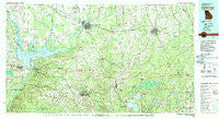
~ Bainbridge GA topo map, 1:100000 scale, 30 X 60 Minute, Historical, 1978, updated 1980
Bainbridge, Georgia, USGS topographic map dated 1978.
Includes geographic coordinates (latitude and longitude). This topographic map is suitable for hiking, camping, and exploring, or framing it as a wall map.
Printed on-demand using high resolution imagery, on heavy weight and acid free paper, or alternatively on a variety of synthetic materials.
Topos available on paper, Waterproof, Poly, or Tyvek. Usually shipping rolled, unless combined with other folded maps in one order.
- Product Number: USGS-5365076
- Free digital map download (high-resolution, GeoPDF): Bainbridge, Georgia (file size: 28 MB)
- Map Size: please refer to the dimensions of the GeoPDF map above
- Weight (paper map): ca. 55 grams
- Map Type: POD USGS Topographic Map
- Map Series: HTMC
- Map Verison: Historical
- Cell ID: 67089
- Scan ID: 247624
- Imprint Year: 1980
- Woodland Tint: Yes
- Aerial Photo Year: 1976
- Edit Year: 1978
- Datum: NAD27
- Map Projection: Universal Transverse Mercator
- Map published by United States Geological Survey
- Map Language: English
- Scanner Resolution: 600 dpi
- Map Cell Name: Bainbridge
- Grid size: 30 X 60 Minute
- Date on map: 1978
- Map Scale: 1:100000
- Geographical region: Georgia, United States
Neighboring Maps:
All neighboring USGS topo maps are available for sale online at a variety of scales.
Spatial coverage:
Topo map Bainbridge, Georgia, covers the geographical area associated the following places:
- Oak Knoll Estates - Hardin Heights - Baum - Homestead Ridge - Brownlee - Rock Bluff - Laingkat - Midway - Recovery - Ocheesee Landing - Harbinwood Estates - Providence - El Destinado - Desser - Douglas City - Sneads - Roddenberry - Rocky Hill - Hannatown - Lake Jackson - Steam Mill - Tamathli (historical) - Bethany - Mount Olive (historical) - Woodland - Akridge - Wadesboro - Attapulgus - Elpino - Juniper - Pleasant Grove - Long Branch - Otisco - Littman - Felkel - Sofkee (historical) - Florence - Osochi (historical) - Yamassee (historical) - River Junction - Inwood - Faceville - Paradise Acres - Brinson - Mount Pleasant - Reno - Reynoldsville - Nickleville - Pebble Hill - Pleasant Hill (historical) - Branchville - Chattahoochee - Blocker - Shady Grove - Freemont - Bethel - Centerville - Bainbridge - Concord - Fairchild - Boydville - Black Creek - Calvary - Iamonia - Pine Park - Butler (historical) - Rosedale - West Bainbridge - Cairo - Smiths Landing - Topkegaiga (historical) - Bellwood Estates - Bridle Path Acres - Lynn - Orange Springs - Dawesville - Sycamore - Ocheesee Gardens - Capel - Miccosukee - Sawdust - Shady Rest - Gretna - Ochlocknee - Gibson - Hinson - Peck - Meridian - Ocklockonee (historical) - Ohathlockhouchy (historical) - Hyhappo (historical) - Amsterdam - Cyrene - Hiamonee (historical) - Oak Grove - Sinai - Climax - Hardaway - Beachton - Magnolia
- Map Area ID: AREA3130.5-85-84
- Northwest corner Lat/Long code: USGSNW31-85
- Northeast corner Lat/Long code: USGSNE31-84
- Southwest corner Lat/Long code: USGSSW30.5-85
- Southeast corner Lat/Long code: USGSSE30.5-84
- Northern map edge Latitude: 31
- Southern map edge Latitude: 30.5
- Western map edge Longitude: -85
- Eastern map edge Longitude: -84


