
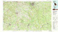
~ Athens GA topo map, 1:100000 scale, 30 X 60 Minute, Historical, 1980, updated 1981
Athens, Georgia, USGS topographic map dated 1980.
Includes geographic coordinates (latitude and longitude). This topographic map is suitable for hiking, camping, and exploring, or framing it as a wall map.
Printed on-demand using high resolution imagery, on heavy weight and acid free paper, or alternatively on a variety of synthetic materials.
Topos available on paper, Waterproof, Poly, or Tyvek. Usually shipping rolled, unless combined with other folded maps in one order.
- Product Number: USGS-5365072
- Free digital map download (high-resolution, GeoPDF): Athens, Georgia (file size: 33 MB)
- Map Size: please refer to the dimensions of the GeoPDF map above
- Weight (paper map): ca. 55 grams
- Map Type: POD USGS Topographic Map
- Map Series: HTMC
- Map Verison: Historical
- Cell ID: 67075
- Scan ID: 247619
- Imprint Year: 1981
- Woodland Tint: Yes
- Aerial Photo Year: 1974
- Edit Year: 1980
- Datum: NAD27
- Map Projection: Universal Transverse Mercator
- Map published by United States Geological Survey
- Map Language: English
- Scanner Resolution: 600 dpi
- Map Cell Name: Athens
- Grid size: 30 X 60 Minute
- Date on map: 1980
- Map Scale: 1:100000
- Geographical region: Georgia, United States
Neighboring Maps:
All neighboring USGS topo maps are available for sale online at a variety of scales.
Spatial coverage:
Topo map Athens, Georgia, covers the geographical area associated the following places:
- Essex - Harbin - Covington - Rose Garden - Salem Village - Red Fox - Saddleback Estates - Greensboro - Overlook Point - Buck Creek - Moss Side - Westgate Park - Victoria Station - Clarkedale - Willow Woods - Danson Woods - North High Shoals - Country Wood - Knights Landing - Compton Woods - Tallassee Farms - Homes of Mansfield - Horseshoe Springs - Woodhaven High Ridge - Beacon Heights - Coventry - Westchester - Stephens - Sugar Creek - Holly Hills - Hub Junction - Milstead - Almon - Dorsey - Bogart - Bethany - Rogers Heights - Walkers Park - Farmington - Hazelbrand Acres - Riverhaven Estates - Quail Run - Durham Town - Alcovy Forest - Winder - Spartan Lane - Ebenezer - Fountain Hill (historical) - Apalachee - Rebel Hill - Idylwood - Elder Heights - Hidden Pines - Hillcrest - Turkey Creek Estates - Belmont - Waterford - Alcovy Mobile Home Park - Melody - Highpoint Mobile Home Park - Starrsville - Forest Hills - North Place - Russell - Woodland Acres - Brandy Shoals - Greenmont - Temperance Bell - Overlook Lake - Millers Glen - Carey - Sunny Acres - Hutchins - Riverside Hills - Salem Cove - Twin Oaks - Bishop - Barrow Heights - Eastmeadow - Salem Meadows - Cambridge Forest - Lake Wildwood - Chadds Walk - Beaver Creek - Plum Orchard - Laurel Chase - Veazey - Country View - Loganville - Cedar Shoals Estates - Oconee Heights - Poplar Springs - The Briars - Saddle Club Estates - Skyline - Hunters Ridge - Acadia Woods - Cobbham (historical) - Athens - Oakwood
- Map Area ID: AREA3433.5-84-83
- Northwest corner Lat/Long code: USGSNW34-84
- Northeast corner Lat/Long code: USGSNE34-83
- Southwest corner Lat/Long code: USGSSW33.5-84
- Southeast corner Lat/Long code: USGSSE33.5-83
- Northern map edge Latitude: 34
- Southern map edge Latitude: 33.5
- Western map edge Longitude: -84
- Eastern map edge Longitude: -83


