
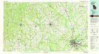
~ Albany GA topo map, 1:100000 scale, 30 X 60 Minute, Historical, 1981, updated 1982
Albany, Georgia, USGS topographic map dated 1981.
Includes geographic coordinates (latitude and longitude). This topographic map is suitable for hiking, camping, and exploring, or framing it as a wall map.
Printed on-demand using high resolution imagery, on heavy weight and acid free paper, or alternatively on a variety of synthetic materials.
Topos available on paper, Waterproof, Poly, or Tyvek. Usually shipping rolled, unless combined with other folded maps in one order.
- Product Number: USGS-5365066
- Free digital map download (high-resolution, GeoPDF): Albany, Georgia (file size: 27 MB)
- Map Size: please refer to the dimensions of the GeoPDF map above
- Weight (paper map): ca. 55 grams
- Map Type: POD USGS Topographic Map
- Map Series: HTMC
- Map Verison: Historical
- Cell ID: 67024
- Scan ID: 247616
- Imprint Year: 1982
- Woodland Tint: Yes
- Aerial Photo Year: 1974
- Edit Year: 1981
- Datum: NAD27
- Map Projection: Universal Transverse Mercator
- Map published by United States Geological Survey
- Map Language: English
- Scanner Resolution: 600 dpi
- Map Cell Name: Albany
- Grid size: 30 X 60 Minute
- Date on map: 1981
- Map Scale: 1:100000
- Geographical region: Georgia, United States
Neighboring Maps:
All neighboring USGS topo maps are available for sale online at a variety of scales.
Spatial coverage:
Topo map Albany, Georgia, covers the geographical area associated the following places:
- Florary - Mossy Dell - Westwood - Woodbridge - Sumter - Groveland - Harmon Heights - Kalmon - Elon Village - Riverdale - Palmyra Homes - Springfield - Chenube (historical) - Walters - Butler Subdivision - Brierwood - Hedrick Park - Colonial Village - Cleveland Heights - Gillionville Forest - Avondale - DeSoto - Aycock Mill - Flintside - Cotton Hill - Plantation Hills - Pineview - Green Acres - Catalina Beach Estates - Jackson Heights - River Road - Sunnyland - Wades - Springvale - Northend Addition - Pecan Terrace - Brooksville - Whispering Pines - Eastgate - Hillingdon - Gailshar Gardens - Flintland - Brookhollow - Benevolence - Country Club Estates - Valley Park - Coachman Park - Chokee - Shellman - Edison - Hillcrest - Saint Andrews - Dickey - Hotalihuyana (historical) - Stroms - Four Points - Pecan - Hillside - Pointe North - Radium Gardens - West Highland - Palmyra Acres - Palmyra - Belmont (historical) - Jones Crossing - Winterwood - Edwards (historical) - Avalon - Eleanor Village - Parksville - Highland Park - Holt - Radium Springs - Cherokee Heights - Dosaga - Oakland - Peterson Hill - Woodland - Croxton Crossroads - Parrott - Southwind - Gore - Morgan - Chambliss - East Towne - Leesburg - Rawson Park - Pachitla - Brentwood - Coles - Eugemar - Mockingbird Estates - Tompkins Village - Relswood Terrace - Bottsford - Clearview - Cedar Heights - Leveretts - Hollywood - Chickasawhatchee
- Map Area ID: AREA3231.5-85-84
- Northwest corner Lat/Long code: USGSNW32-85
- Northeast corner Lat/Long code: USGSNE32-84
- Southwest corner Lat/Long code: USGSSW31.5-85
- Southeast corner Lat/Long code: USGSSE31.5-84
- Northern map edge Latitude: 32
- Southern map edge Latitude: 31.5
- Western map edge Longitude: -85
- Eastern map edge Longitude: -84


