
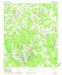
~ Tyrone GA topo map, 1:24000 scale, 7.5 X 7.5 Minute, Historical, 1965, updated 1983
Tyrone, Georgia, USGS topographic map dated 1965.
Includes geographic coordinates (latitude and longitude). This topographic map is suitable for hiking, camping, and exploring, or framing it as a wall map.
Printed on-demand using high resolution imagery, on heavy weight and acid free paper, or alternatively on a variety of synthetic materials.
Topos available on paper, Waterproof, Poly, or Tyvek. Usually shipping rolled, unless combined with other folded maps in one order.
- Product Number: USGS-5364432
- Free digital map download (high-resolution, GeoPDF): Tyrone, Georgia (file size: 11 MB)
- Map Size: please refer to the dimensions of the GeoPDF map above
- Weight (paper map): ca. 55 grams
- Map Type: POD USGS Topographic Map
- Map Series: HTMC
- Map Verison: Historical
- Cell ID: 46239
- Scan ID: 247193
- Imprint Year: 1983
- Woodland Tint: Yes
- Photo Revision Year: 1982
- Aerial Photo Year: 1981
- Edit Year: 1982
- Datum: NAD27
- Map Projection: Polyconic
- Map published by United States Geological Survey
- Map Language: English
- Scanner Resolution: 600 dpi
- Map Cell Name: Tyrone
- Grid size: 7.5 X 7.5 Minute
- Date on map: 1965
- Map Scale: 1:24000
- Geographical region: Georgia, United States
Neighboring Maps:
All neighboring USGS topo maps are available for sale online at a variety of scales.
Spatial coverage:
Topo map Tyrone, Georgia, covers the geographical area associated the following places:
- Greers Mountain - Smiths Crossroads - Whitfield Farms - Edgewater - Twigs Corner - Smoke Rise Plantation - Fetlock Meadows - Golfview - Aberdeen - Center Green - Windgate Forest - Rosemont - Tapestry - Peachtree Walk - Tinsley Mill Village - Sawmill Trace - Braelinn Green - Tyrone - Sandown Creek - The Cloister - Sweetwater Oaks - Wickerhill - Country Downs - Heritage Farms - Camp Creek Estates - Peachtree Villas - Tyrone Acres - Spooner Ridge - Burnham Woods - Valleywood Corners - Treillage - Shadowood - Spyglass Hill - Shake Rag - The Summit - Peachtree City - Woodsmill - Chestnutfield - Rockspray - Caramore - Everhill - The Highlands - Graceland - Briarhill - Brookwood - Briarwood Acres - Raintree East - Groveland - North Peachtree Estates - Wynnmeade - McIntosh Corner - The Terraces - Saint Andrews Square - Clover Reach - Creekside Crossing Estates - Timberidge - Braelinn Courts - Cobblestone Creek - Lake Forest Glen - Robinsons Bend Estates - Fischers Crossroad - Sandy Creek - Westpark - Lake Forest Cove - Fishers Bank - Magnolia Farms - Stoney Brook Plantation - Marnelle Mobile Home Park - Stop - Wedgewood - Stevens Forest - Wisdom Woods - Parkway Estates - Piney Knoll - Fayette Villa Estates - Windsong - Robinson Wood Estates - Overlook - Ridgefield - Pinegate - Greensway - Belle Grove - Ridgelake - Ledgewood - Kingsridge - Fernwood - Lakeside - The Arbors - Dover Square - Jennings Yard - Bridger Point
- Map Area ID: AREA33.533.375-84.625-84.5
- Northwest corner Lat/Long code: USGSNW33.5-84.625
- Northeast corner Lat/Long code: USGSNE33.5-84.5
- Southwest corner Lat/Long code: USGSSW33.375-84.625
- Southeast corner Lat/Long code: USGSSE33.375-84.5
- Northern map edge Latitude: 33.5
- Southern map edge Latitude: 33.375
- Western map edge Longitude: -84.625
- Eastern map edge Longitude: -84.5


