
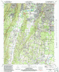
~ Fort Oglethorpe GA topo map, 1:24000 scale, 7.5 X 7.5 Minute, Historical, 1982, updated 1988
Fort Oglethorpe, Georgia, USGS topographic map dated 1982.
Includes geographic coordinates (latitude and longitude). This topographic map is suitable for hiking, camping, and exploring, or framing it as a wall map.
Printed on-demand using high resolution imagery, on heavy weight and acid free paper, or alternatively on a variety of synthetic materials.
Topos available on paper, Waterproof, Poly, or Tyvek. Usually shipping rolled, unless combined with other folded maps in one order.
- Product Number: USGS-5361822
- Free digital map download (high-resolution, GeoPDF): Fort Oglethorpe, Georgia (file size: 18 MB)
- Map Size: please refer to the dimensions of the GeoPDF map above
- Weight (paper map): ca. 55 grams
- Map Type: POD USGS Topographic Map
- Map Series: HTMC
- Map Verison: Historical
- Cell ID: 15974
- Scan ID: 245725
- Imprint Year: 1988
- Woodland Tint: Yes
- Aerial Photo Year: 1975
- Edit Year: 1982
- Field Check Year: 1975
- Datum: NAD27
- Map Projection: Transverse Mercator
- Map published by United States Geological Survey
- Map Language: English
- Scanner Resolution: 600 dpi
- Map Cell Name: Fort Oglethorpe
- Grid size: 7.5 X 7.5 Minute
- Date on map: 1982
- Map Scale: 1:24000
- Geographical region: Georgia, United States
Neighboring Maps:
All neighboring USGS topo maps are available for sale online at a variety of scales.
Spatial coverage:
Topo map Fort Oglethorpe, Georgia, covers the geographical area associated the following places:
- Eagle Cliff - Haysville - Cannon Crossing - Warren Terrace - Pinewood Estates - White Oak - Fantasy Hills - Red Belt - Fairlawn Acres - Lookout Mountain - Woodland Hills - Valley View - Fort Oglethorpe - Cedar Hill - Spencer Hills - Green Hills - Milbro Heights - Dewberry Town - Chattanooga Valley - Gerber (historical) - Wallaceville - Saint Elmo - Lytle - Laurelwood Estates - Lookout Mountain - Shadynook - Georgia Acres - Cloud Springs - Mountain View - Flintstone - Piney Woods - Happy Valley - Midway - Moons - Cenchat - Orchard Hills - Dickey (historical) - Fairview - Rock City - Park City - Green Acres - South Rossville - Mission Oaks - John Ross Estates - Robertsville - Beverly Hills - Rossville - Lakeview - Blowing Spring
- Map Area ID: AREA3534.875-85.375-85.25
- Northwest corner Lat/Long code: USGSNW35-85.375
- Northeast corner Lat/Long code: USGSNE35-85.25
- Southwest corner Lat/Long code: USGSSW34.875-85.375
- Southeast corner Lat/Long code: USGSSE34.875-85.25
- Northern map edge Latitude: 35
- Southern map edge Latitude: 34.875
- Western map edge Longitude: -85.375
- Eastern map edge Longitude: -85.25


