
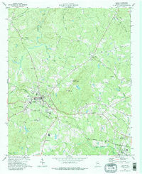
~ Dallas GA topo map, 1:24000 scale, 7.5 X 7.5 Minute, Historical, 1973, updated 1988
Dallas, Georgia, USGS topographic map dated 1973.
Includes geographic coordinates (latitude and longitude). This topographic map is suitable for hiking, camping, and exploring, or framing it as a wall map.
Printed on-demand using high resolution imagery, on heavy weight and acid free paper, or alternatively on a variety of synthetic materials.
Topos available on paper, Waterproof, Poly, or Tyvek. Usually shipping rolled, unless combined with other folded maps in one order.
- Product Number: USGS-5361388
- Free digital map download (high-resolution, GeoPDF): Dallas, Georgia (file size: 13 MB)
- Map Size: please refer to the dimensions of the GeoPDF map above
- Weight (paper map): ca. 55 grams
- Map Type: POD USGS Topographic Map
- Map Series: HTMC
- Map Verison: Historical
- Cell ID: 69816
- Scan ID: 245486
- Imprint Year: 1988
- Woodland Tint: Yes
- Visual Version Number: 2
- Aerial Photo Year: 1972
- Field Check Year: 1973
- Datum: NAD27
- Map Projection: Transverse Mercator
- Map published by United States Geological Survey
- Map Language: English
- Scanner Resolution: 600 dpi
- Map Cell Name: Dallas
- Grid size: 7.5 X 7.5 Minute
- Date on map: 1973
- Map Scale: 1:24000
- Geographical region: Georgia, United States
Neighboring Maps:
All neighboring USGS topo maps are available for sale online at a variety of scales.
Spatial coverage:
Topo map Dallas, Georgia, covers the geographical area associated the following places:
- Hopecastle Forest - Lost Meadows - Echo Ridge - Brookwood - Etta (historical) - Country Acres - Wildwood - Denton Manor - New Hope - Musket Ridge - Mountain Trace - Sunny Acres - Gunnell Place - Oak Dale Manor - Meadow Lark - Twelve Oaks - Dallas - Macland Springs - Wood Valley - Mount Tabor Trace - Saddle Up Estates - Westward Ho - Forrister - Devonshire - Tabor Estates - Cobb Estates - Indian Lake - Canaan Heights - Forest Echo - Hiram - Mill Creek Station - Hart Circle - Spanish Trails - Greenacres - Cross Creek - Hickory Gap - Forest Creek Colony - Plantation Estates - Hasford Estates - Coppermine Estates - Acorn Tree - Wilbanks Circle - Keener Estates - Rock Falls Estates - Carrington Chase - Oak Haven - Ponderosa Estates - White Forest - Burnt Hickory Acres - Roxana - Indian Springs - Beverly Estates - Winndale - Park Place - Country Square - Sunset Hills - Piney Woods Manor - Hampton Estates - Brock - Windmill Creek - Heritage Estates - Hidden Oaks - Brooks Estates
- Map Area ID: AREA3433.875-84.875-84.75
- Northwest corner Lat/Long code: USGSNW34-84.875
- Northeast corner Lat/Long code: USGSNE34-84.75
- Southwest corner Lat/Long code: USGSSW33.875-84.875
- Southeast corner Lat/Long code: USGSSE33.875-84.75
- Northern map edge Latitude: 34
- Southern map edge Latitude: 33.875
- Western map edge Longitude: -84.875
- Eastern map edge Longitude: -84.75


