
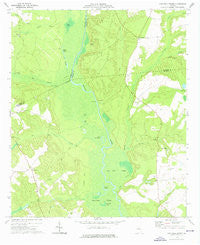
~ Cow Hell Swamp GA topo map, 1:24000 scale, 7.5 X 7.5 Minute, Historical, 1974, updated 1976
Cow Hell Swamp, Georgia, USGS topographic map dated 1974.
Includes geographic coordinates (latitude and longitude). This topographic map is suitable for hiking, camping, and exploring, or framing it as a wall map.
Printed on-demand using high resolution imagery, on heavy weight and acid free paper, or alternatively on a variety of synthetic materials.
Topos available on paper, Waterproof, Poly, or Tyvek. Usually shipping rolled, unless combined with other folded maps in one order.
- Product Number: USGS-5361272
- Free digital map download (high-resolution, GeoPDF): Cow Hell Swamp, Georgia (file size: 9 MB)
- Map Size: please refer to the dimensions of the GeoPDF map above
- Weight (paper map): ca. 55 grams
- Map Type: POD USGS Topographic Map
- Map Series: HTMC
- Map Verison: Historical
- Cell ID: 10428
- Scan ID: 245419
- Imprint Year: 1976
- Woodland Tint: Yes
- Aerial Photo Year: 1973
- Field Check Year: 1974
- Datum: NAD27
- Map Projection: Transverse Mercator
- Map published by United States Geological Survey
- Map Language: English
- Scanner Resolution: 600 dpi
- Map Cell Name: Cow Hell Swamp
- Grid size: 7.5 X 7.5 Minute
- Date on map: 1974
- Map Scale: 1:24000
- Geographical region: Georgia, United States
Neighboring Maps:
All neighboring USGS topo maps are available for sale online at a variety of scales.
Spatial coverage:
Topo map Cow Hell Swamp, Georgia, covers the geographical area associated the following places:
- Clear Lake - Hall Landing - Goat Pond - Kellams Creek - Post Cemetery - Hightower Cemetery - Evergreen Church - Gin Branch - Goose Creek - Flat Creek - Yorks Dead River - Cow Hell Swamp - Gin Branch - Halls Landing - Sarchett Lake - Holly Springs Church - Fords Creek - Tuckers Flat - Deep Creek - Holly Grove Cemetery - Plummer Cemetery - Moody Cemetery - Tobe Lake - Kellams Cemetery - Big Sandy Creek - Little Sandy Creek - Jack Lake - Dry Creek - Deep Creek - Londonfield Cemetery - Salem Church - Messers Bridge - Stanley Cemetery - Cullen Grove Church - Old Evergreen School (historical) - Deep Creek Landing - Salem Cemetery - Herberts Chapel - Buckeye Creek - Chinaberry Ranch Airport - Walker Cemetery - Guyton Cemetery - Bowens Lake - Beaverdam Swamp - Cullens Store (historical) - Wynn Lake
- Map Area ID: AREA32.7532.625-83-82.875
- Northwest corner Lat/Long code: USGSNW32.75-83
- Northeast corner Lat/Long code: USGSNE32.75-82.875
- Southwest corner Lat/Long code: USGSSW32.625-83
- Southeast corner Lat/Long code: USGSSE32.625-82.875
- Northern map edge Latitude: 32.75
- Southern map edge Latitude: 32.625
- Western map edge Longitude: -83
- Eastern map edge Longitude: -82.875


