
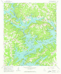
~ Chestatee GA topo map, 1:24000 scale, 7.5 X 7.5 Minute, Historical, 1964, updated 1973
Chestatee, Georgia, USGS topographic map dated 1964.
Includes geographic coordinates (latitude and longitude). This topographic map is suitable for hiking, camping, and exploring, or framing it as a wall map.
Printed on-demand using high resolution imagery, on heavy weight and acid free paper, or alternatively on a variety of synthetic materials.
Topos available on paper, Waterproof, Poly, or Tyvek. Usually shipping rolled, unless combined with other folded maps in one order.
- Product Number: USGS-5361076
- Free digital map download (high-resolution, GeoPDF): Chestatee, Georgia (file size: 14 MB)
- Map Size: please refer to the dimensions of the GeoPDF map above
- Weight (paper map): ca. 55 grams
- Map Type: POD USGS Topographic Map
- Map Series: HTMC
- Map Verison: Historical
- Cell ID: 8400
- Scan ID: 245306
- Imprint Year: 1973
- Woodland Tint: Yes
- Aerial Photo Year: 1962
- Field Check Year: 1964
- Datum: NAD27
- Map Projection: Polyconic
- Map published by United States Geological Survey
- Map Language: English
- Scanner Resolution: 600 dpi
- Map Cell Name: Chestatee
- Grid size: 7.5 X 7.5 Minute
- Date on map: 1964
- Map Scale: 1:24000
- Geographical region: Georgia, United States
Neighboring Maps:
All neighboring USGS topo maps are available for sale online at a variety of scales.
Spatial coverage:
Topo map Chestatee, Georgia, covers the geographical area associated the following places:
- White - Weatherford - Whitmire - Looper Lake - Point View Landing - Moore - Twin Rivers - Mundys Point - Pine Forest - Cameron Point - Holiday Heights - Chestatee - Cherokee Trail - Wolfs Head - Lake Farm - Springdale - Serene Shores - Crown Point - Fox Trace - Sardis Shores - Venture Cove - Pinecrest Heights - Pine Haven - McEver - Absalom (historical) - Cherokee Hills - Westview - Summer Point - Holiday Hills - Sidney on Lanier - Springdale Forest - Barnes - Pine Hills - Trudy - Lanier Northwest - Chestatee North - Vickers - Beach Haven Heights - Fran Mar Heights - Reed - Tanner - Mountain View - Maple Forge - Mill Ridge - Lake Ranch
- Map Area ID: AREA34.37534.25-84-83.875
- Northwest corner Lat/Long code: USGSNW34.375-84
- Northeast corner Lat/Long code: USGSNE34.375-83.875
- Southwest corner Lat/Long code: USGSSW34.25-84
- Southeast corner Lat/Long code: USGSSE34.25-83.875
- Northern map edge Latitude: 34.375
- Southern map edge Latitude: 34.25
- Western map edge Longitude: -84
- Eastern map edge Longitude: -83.875


